Sheridan Hollow, Albany, New York
[1] This is due to the identity of the Hollow being subsumed into its larger neighbor Arbor Hill, for instance news stories of events are often accredited to the wrong neighborhood.
[2][3] Being on undesirable land for development in colonial times, growth was slow in the Hollow and the neighborhood was populated through the centuries by a series of ethnic groups new to Albany, such as the Irish, Polish, and African Americans.
The creek and associated ravine were passed over in the initial growth of settlement at Beverwyck and colonial Albany until the late 1700s.
[4] The northern edge of the 1750 Albany stockade ran along the southern rim of the Sheridan Hollow ravine, along what is now Columbia Street.
A 1758 British Army map shows a road extending through the ravine, and in 1762 the city's Common Council ordered a "Publick Street remain in the Foxes Creek" up to and "as farr as the Schytt Bergie", the Schytt Bergie (Dutch for "Dung Hill"), being a hill made of deposited horse dung between present-day Central and Western avenues.
[6] In 1763 the land north from Foxes Creek to the city line, which was the northern rim of the Hollow and future Clinton Avenue, was auctioned off primarily to tanners.
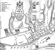
Clinton Avenue (Patroon Street at the time) being the northern border of the city this plan included Sheridan Hollow.
[13][14] Dinah Jackson, the first known African American property owner in Albany, owned several lots throughout Sheridan Hollow.
[19] The western section of the neighborhood bordering West Hill became dominated by Polish immigrants who built St. Casimir's Church in 1893, which closed in 2003.
[22] Starting in the mid-1990s the eastern edge of Sheridan Hollow began to develop as part of a revival of Downtown Albany.
[23] A Hampton Inn and Suites was built nearby on Chapel Street between Sheridan and Monroe in 2005, it hosts a local restaurant and bar, Yono's.
[25] Plans by the city are for more residential units at this end of the Hollow, in order to bring more people within walking distance of downtown.
[26] As part of the construction for a 1,380 car, 7-story parking garage by the state of New York along the southern rim of the Hollow, an archaeological study was performed to determine if the African American burial grounds shown on the 1790 De Witt plan were present.
[8] Whereas most other ravines and creeks in Albany were filled in throughout the centuries, Sheridan Hollow was too deep,[8] so growth in this part of the city remained stagnant and led to the isolation of Arbor Hill from Downtown.