Harlem River
The northern stretch, also called the Spuyten Duyvil ("spewing devil") Creek, has been significantly altered for navigation purposes.
[citation needed] Historically, the west bank of the Harlem River was also an amusement destination.
[2] In the 1890s, the City of New York built a racetrack for horses, the Harlem River Speedway, along the riverbank of the park;[3] the project started construction in 1894[4] and opened in July 1898.
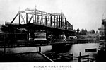
All other movable bridges on the Harlem River provide at least 24 feet (7.3 m) of clearance while closed, so boats and ships requiring between 5 and 24 feet (1.5 and 7.3 m) of clearance need only have one bridge swing open.
Top: closed positionbottom: open position Download coordinates as: Notes Further reading 40°50′05.00″N 73°56′02.85″W / 40.8347222°N 73.9341250°W / 40.8347222; -73.9341250 (Harlem River)