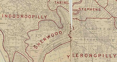
Shire of Sherwood
[7] Three shipwrecked and disoriented ticket of leave convicts, Pamphlet, Finnegan and Parsons in June 1823 were walking and were diverted by the river to the mouth of Oxley Creek.
[9][7] Several hills, part of a system of low ridges extending from Spring Mountain sixteen miles to the south-west, ranged from 100 to 200 feet.
Early selectors found evidence of Aboriginal sites, believing a circular floating island in the large Oxley Point (Chelmer) swamp was a bora ring.
Speculators included Governor Bowen's secretary, John Bramston, who purchased land at Oxley Point and Charles Blakeney, Frank McDougall and Arnold Wienholt, who served in either the upper or lower houses of the colonial legislature during the 1860s, but did not reside locally.
Arthur M. Francis, a selector of 1863 and an acquaintance of Governor, Samuel Blackall represented the large East Moreton Electorate in the Queensland Legislative Assembly between 1867 and 1870.
[7] In the absence of a local police station until 1876, a moral influence was required due to the temptation of hotels at Oxley and Rocky Waterholes (Rocklea).
Influenced by the three Sherwood Protestant church's congregations, public opinion within the Shire ensured that hotel ownership remained confined to Oxley, with the result that suburbs from Corinda to Chelmer were free from any establishment which sold alcohol.
[21] Hassall, who in 1899, retired in his mid-seventies, the younger Pollock continued his ministry into the early 1900s actively supporting social issues important to his congregation.
These meetings, held regularly in aid of building funds originated in the early 1860s as part of the planning for the erection of the Primitive Methodist Church near Rocky Waterholes (Rocklea).
[27] Sherwood primary school head teachers were also prominent: Hugh Welch as a Presbyterian elder; Eskiel Larter, choir master at St. Matthews; and Thomas Fielding,[28] a long term lay supporter of both the local Methodist Church.
Pollock, while disposed towards conservative ideals of other Protestant clergy, exhibited a progressive attitude with regard to the involvement of the church in industrial disputes.
[7] Following persistent support by Pollock for aged pensions, the Presbyterian General Assembly adopted his resolution in 1906 that recognized the duty of all Christian communities to care for the poor.
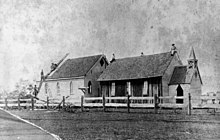
[7] Local residents in 1864 held working bees to erect a non-denominational slab church at Oxley West, with the Sunday school supervised by Arthur Francis.
[33] Parishioners as well as Sherwood Shire residents contributed financially to the construction of a new church, enabling the foundation stone to be laid within three years.
[7][35] In 1880 at Seventeen Mile Rocks, another Methodist sect, the Bible Christians, constructed a bark and shingle building, their preachers traveling by river from Ipswich.
[7] The first settlers on the hill in Corinda: Alexander Boyd, William Gray, and Arthur Francis and his wife Angela, were influential, due to their association with the religious and educational activities which helped stabilise the local area.
With escalating criminal and immoral activities in the community it motivated this reversal by Protestant religions, who in 1875 had previously supported a secular education in government schools.
[7] The origins of the word 'Corinda' and the naming of the railway station and suburb can be derived from a land development in 1888, called 'Corinda Township Estate' on lots 99 and 100 of the Parish of Oxley.
By 1891, when the Shire of Sherwood was proclaimed, the population numbered 2331, there being at least 30% of male residents listed in postal directories who followed urban rather than farming occupations.
[53] Further north in Oxley West, the original Sherwood Township, briefly named Rowland after the government official who surveyed it in the late 1870s, bordered the northern side of the road to Rocky Waterholes (Rocklea).
[7][63] At Graceville during the early 1890s, newspaper proprietor and former cabinet minister, Charles H. Buzzacott, resided at the two storeyed 'Verney House' with its view of the Brisbane River.
William Grey, and called Consort Cliff in Corinda was bought by Mr. Charles Collins, manager of the Union Bank in Brisbane in the 1880s, where he built a house and named it 'Ardoyne'.
During the 1890s and early 1900s, with streets unmarked, middle class residents recorded in post office directories and electoral rolls, had the names of their homes as part of their address.
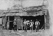
In 1899, William Brittain transferred the company brickworks from Booval in Ipswich, taking advantage of the clay ground to the south-west of Oxley railway station.
[77] Other elected members included surveyor, Thomas O'Connor; distillery operator, Samuel Knight; newspaper proprietor, Charles Buzzacott; and commission agents, Rhodes Whitaker and William Berry.
By 1921, senior office-bearers included Augustus Cecil Elphinstone of Corinda, representing the Oxley Electorate in the Queensland Legislative Assembly, and solicitors John Cannan junior and Arthur Baynes, both of Chelmer.
This led to the rapid increase of tennis courts in the large allotments to the west of the railway, where social games were played among the middle class and their invited guests.
The scout movement contained a moral code outlined by British Boer War hero, Robert Stephenson Smythe Baden-Powell, in his book 'Scouting for Boys'.
The adult supporters committee comprised the three local Protestant clergy, the Sherwood primary school head teacher and a prominent Corinda resident, Thomas Hall, who served as president.
[7] There was a negative response by local residents to a powder magazine established in the mid-1880s near the Brisbane River at Sherwood where ammunition was stored on behalf of the then Queensland Navy.