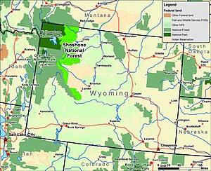
Shoshone National Forest
Shoshone National Forest is a part of the Greater Yellowstone Ecosystem, a nearly unbroken expanse of federally protected lands encompassing an estimated 20,000,000 acres (8,100,000 ha).
Shoshone National Forest is home to all of the original plant and animal species that were present when explorers such as John Colter and Jim Bridger first visited the region.
[4] The forest provided an abundance of game meat, wood products, and shelter during the winter months from the more exposed high plains to the east.
Subsequent amendments to the treaty reduced the actual acreage to approximately 2,000,000 acres (810,000 ha) and is known today as the Wind River Indian Reservation.
[9] The oldest deposits in the cave yielded prismatic stone blades and other artifacts created by paleoindians and the surrounding soils were radiocarbon dated to 7,300 BC.
With the decline of the fur trade in the late 1840s and much of the prized beaver long since made scarce by over-trapping, few explorers entered the forest over the next few decades.
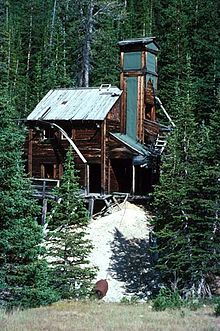
[18][19] After the end of the mining era, numerous camps were established by the Civilian Conservation Corps to help combat unemployment during the Great Depression of the 1930s.
The camps housed groups of unemployed men who were paid by the federal government to build roads, hiking trails, and campgrounds for future travelers to the Yellowstone region.
[20] Visitation to national forests like Shoshone increased dramatically after World War II with the advent of better roads and accessibility to the region.
[28] Additionally, low-scale mineral extraction and oil and gas exploration and recovery are also conducted, though in Shoshone National Forest this has become less common due to a consensus to protect the natural surroundings.
[30] The U.S. Forest Service provides guidelines and enforces environmental regulations to ensure that resources are not overexploited and that necessary commodities are available for future generations, though conservation groups have voiced concerns over the management practices of the leasing program and especially cattle overgrazing problems.
[34][35] Lower elevations often have sagebrush and grass-dominated vegetation types, while forested areas are dominated by various combinations of tree and shrub species.
Among them, the whitlow grass, fremont bladderpod, shoshonea, and the north fork Easter daisy provide vivid white and yellow flowers during the spring and summer.
[40] The forest service is addressing the situation by performing controlled burns, selling dead trees as firewood, timber harvesting and spraying the highest value areas.
Visitors are mandated to store their food in their vehicles or in steel containers found in campgrounds, and bear-proof trash receptacles are located in the front-country zones throughout the forest.
[44] The wolf was delisted as endangered once their population levels had reached management objectives and limited hunting of wolves was permitted in the forest starting in 2012.
[48] The Canada lynx was native to the forest, but no known populations may still exist due to the rarity of its primary food source, the Snowshoe hare.
[50] Waterfowl such as Western grebe, Northern pintail, Great blue heron and Barrow’s goldeneye have stable populations and rare sightings of Trumpeter swans are reported.
Harlequin duck and northern goshawk are generally rare but management plans were implemented to protect various habitats these two species frequent to try and increase their population numbers.
[51] Amphibians such as the Columbia spotted frog and the boreal toad are considered species of concern because of their high susceptibility to disease, habitat loss and human introduced toxins.
[58] The forest contains four areas of pristine wilderness that have remained largely untouched by human activities such as mining, logging, and road and building construction.
It was in a stand of old growth fir trees in Shoshone National Forest that the Blackwater fire of 1937 killed 15 fighters during a firestorm 35 mi (56 km) west of Cody, Wyoming.
[66] Between the years 1970 and 2012, Shoshone National Forest averaged 25 fires annually, of which half were due to natural ignition from lightning, which accounted for 90 percent of the total acreage burned.
Lastly, the Wind River Indian Reservation also borders on the east, and bisects a smaller southern section which includes the Popo Agie Wilderness and the Washakie Ranger District.
[72] The peaks of the Absaroka are basaltic in origin, having been the result of volcanic activity estimated to have occurred 50 million years ago during the Eocene epoch.
[71] Uplifted approximately 70 million years ago during the Laramide orogeny, the Beartooths consist of vast windswept plateaus and rugged peaks with sheer cliff faces.
[82] Researchers claim that for most of the period that glaciers have been known to exist in the forest, that they have been in a state of general retreat, with glacial mass losses of as much as 25 percent between the years 1985 and 2009.
Scientists have obtained ice cores from the Upper Fremont Glacier and found that there have been measurable changes in the atmosphere over the past several hundred years.
Once a glacier begins retreating, it may fall into disequilibrium and be unable to find mass balance (accumulation versus melting rate) at any size.
Due to the altitude and dryness of the atmosphere, vigorous radiative cooling occurs throughout the year, and exceptional daily temperature variances are not uncommon.