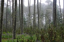
Sierra Madre de Oaxaca pine–oak forests
It is one of a chain of pine–oak forest ecoregions extending along the American Cordillera from Oregon and California in the north to Nicaragua in the south.
The ecoregion covers an area of 14,300 square kilometers (5,500 sq mi), lying above 1,600 metres (5,200 ft) elevation.
The ecoregion is bounded on the east by the humid Oaxacan montane forests, which lie below 1,600 metres (5,200 ft) elevation.
Many communities, notably Ixtlán de Juárez and the Pueblos Mancomunados, among others, strive to conserve their forest through projects including sustainable forestry and selective logging, ecotourism, education projects, and the prohibition of private property within their communities (thus hampering unsustainable development and industry by foreign or outside agents).
Protected areas include Benito Juárez National Park, Cañón del Río Blanco National Park, Tehuacán-Cuicatlán Biosphere Reserve, Hierve El Agua State Park, and the El Bejucal y la Chichihua, La Cruz – Corral de Piedra, La Tierra del Faisán, Comunitaria Santo Domingo Cacalotepec, (Parcela) 70 Z-1 P1-1 (Ejido Chivela), and Nopalera del Rosario voluntary conservation areas.