Preah Sihanouk province
The provincial capital, also called Sihanoukville, is a deep water port city and a steadily growing and diversifying urban center on an elevated peninsula.
[7][8] Preah Sihanouk is divided into four districts, each with a distinct economic character, defined largely by location and access to resources.
[9] In addition to the port and the growing tourism industry, the activities of countless NGOs and international investment have contributed to the rapid economic growth of the province over the course of the last decade.
[10] Primary economic sectors are transport and logistics, process manufacturing, agriculture and fisheries, textiles, and real estate.
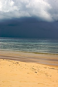
The islands and beaches of Preah Sihanouk Province are an international tourist destination as visitor numbers have risen steadily since the late-20th century.
[19] Som is derived from the Sanskrit word saumya, the original (Rig Vedic) meaning of which was Somā, the 'juice or sacrifice of the moon-god', but evolved into Pali 'moon', 'moonlike' 'name of Shiva'.
[22] Prior to the city's creation in 1955, no recorded settlement on the peninsula existed that was larger than a traditional trading or fishing village.
During the many centuries of pre-Angkorian and Angkorian history – from Funan to Chenla and during the Khmer Empire, regional trade was centered at O Keo (Vietnamese: Óc Eo) in the Mekong Delta, now the province of Rạch Giá in Vietnam.
[23][24] The Chronicle of Samtec Cauva Vamn Juon – one of the 18th and 19th century Cambodian Royal Chronicles – briefly mentions the region as the country was split into three parts during a nine year civil war from 1476 to 1485: "In 1479, Dhammaraja took on the throne at Catumukh (Phnom Penh) and controlled the provinces of Samrong Tong, Thpong, Kompong Saom, Kampot up to the Bassak, Preah Trapeang, Kramuon Sar, Koh Slaket and Peam".
[26] A Cambodian king of the late-18th century, Outey-Reachea III allied with a Chinese pirate,[27] Mac-Thien-Tu, who had established an autonomous polity based in Ha Tien and controlled the maritime network in the eastern part of the Gulf of Thailand.
In 1757 Ha Tien acquired the ports of Kampot and Kompong Som as a reward for Mac's military support of the King of Cambodia.
French Résident Adhemard Leclère wrote: "...Until the 1840s, the Vietnamese governed Kampot and Péam [Mekong Delta], but Kompong Som belonged to Cambodia.
Eyewitness reports give rare insights, as Foreign Secretary Lord Palmerston's agent John Crawfurd reports: "Cambodia was...the Keystone of our policy in these countries, - the King of that ancient Kingdom is ready to throw himself under the protection of any European nation...The Vietnamese were interfering with the trade at Kampot, and this would be the basis of an approach..." Palmerston concluded: "The trade at Kampot - one of the few remaining ports, could never be considerable, in consequence of the main entrance to the country, the Mekong, with all its feeders flowing into the Sea through the territory of Cochin China The country, too, had been devastated by recent Siam - Vietnam wars.
Crawfurd later wrote: "The Cambodians... sought to use intervals of peace in the Siam - Vietnam wars to develop intercourse with outside nations.
Here is a point where the wedge might be inserted, that would open the interior of the Indo-Chinese Peninsula to British Commerce, as the great River of the Cambodians traverses its entire length and even affords communication into the heart of Siam".
It started in Kampot and quickly spread to Veal Rinh, Kampong Seila, and Kompong Som, where the insurgents were led by a Chinese pirate named Quan-Khiem.
After the dissolution of French Indochina in 1954, it became apparent that the steadily tightening control of the Mekong Delta by Vietnam required a solution to gain unrestricted access to the seas.
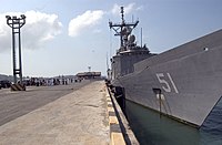
The events surrounding the taking of the US container ship SS Mayaguez and its crew on 12 May 1975 by the Khmer Rouge and the subsequent rescue operation by US Marines played out on the waters of Koh Tang off the coast of Sihanoukville.
[36] On 26 May 2011 the Preah Sihanouk area joined the Paris-based club Les Plus Belles Baies Du Monde ('The most Beautiful Bays in the World').
[38] Preah Sihanouk Province is on the coast of the Gulf of Thailand in southern Cambodia, occupying an area of 2536 km2 that includes the foothills of the Elephant Mountains and a sizable peninsula.
Stung Hauv District in the northwest, only half the size of Prey Nob, has the largest fisheries sector of the province.
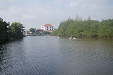
Restaurants along the south bank of the river serve fresh seafood supplied by the local inshore fishing boats.
Other sizable economic sectors of the province are fisheries, aquaculture, agriculture, mining, frozen shrimp processing, the garment industry, the real estate market, and tourism.
[63] The catching and processing of marine fisheries products is undertaken by both small-scale family style operations as well as on a large commercial level.
[70] The province is served by Sihanouk International Airport, 18 kilometres (11 mi) from Sihanoukville town, although as of 2014 it sees limited commercial operation.
The airport's former name, Kaong Kang (កោងកាង, 'mangrove') reflects its site on top of a drained mangrove marsh by the sea in Ream commune in southern Sihanoukville province near National Highway 4.
Some companies offer services to Bangkok, Ho Chi Minh City, and Siem Reap through a connection in Phnom Penh.
[74] The "Southern Line", constructed 1960-1969 with a length of 264 km, connects the Sihanoukville Port Special Economic Zone with the capital Phnom Penh.
In addition, there are other groups: Vietnamese, Chinese, Cham, Thai, French, British, Korean Europeans, Australians, and Americans, due to its status as an international port and a tourist destination.
[80] The inhabitants of Sihanoukville province celebrate all religious, traditional and secular festivities such as Cambodian New Year (April), Chinese New Year (between January and February), Water Festival (November), Pchum Ben (honor to the ancestors in October) and Kathen Ceremony (offerings to the monks), 8 January (Day of Cambodian - Vietnamese Friendship) among others.

and Pierre Lefèvre-Pontalis in 1893
with Cambodian interpreters


Mittakpheap (dark red), Stueng Hav (yellow), Prey Nob (blue), Kampong Seila (green)


