Simi Valley, California
It grew as a bedroom community for the cities in the Los Angeles area and the San Fernando Valley when a freeway was built over the Santa Susana Pass.
[15] The native people who inhabited Simi Valley spoke an interior dialect of the Chumash language, called Ventureño.
Simi Valley's name is derived from the Chumash word Shimiyi, which refers to the stringy, thread-like clouds that typify the region.
[16][17][18] The name could have originated from the strands of mist from coastal fog that move into the Oxnard Plain and wind their way up the Calleguas Creek and the Arroyo Las Posas into Simi Valley.
José de la Guerra y Noriega, a Captain of the Santa Barbara Presidio, who had begun to acquire large amounts of land in California to raise cattle, purchased Rancho Simí from the Pico family in 1842.
As late as February 1877, Juan De la Guerra was reported in county newspapers to be preparing to plant walnuts in the Tapo, which appears to be the final mention of their farming in relation to the original Simí grant.
[28] The Pioneer, or 'American,' period in Simi Valley began with the 96,000-acre purchase of El Rancho Simí by an eastern speculator named Thomas A. Scott (1814–1882), who had made his money as an investor in the Pennsylvania Railroad during the Civil War.
Charles Emerson Hoar was given the title of "first American farmer" by early Simí historian Janet Scott Cameron.
He had purchased the Hummingbird's Nest Ranch in the northeast corner of the Valley, and he leased land from the new owners of the Simí Rancho for raising sheep, already a proven way of making a living.
El Rancho Simí was divided into ranches and farms by that corporation, and advertised for sale to midwestern and New England states.
An investor group, the California Mutual Benefit Colony of Chicago, purchased land and laid out a townsite (located between First and Fifth Streets and from Los Angeles south to Ventura Ave), named it 'Simiopolis' and shipped twelve pre-cut, partially assembled houses from a lumberyard in Chicago via rail to Saticoy, then brought by wagon to Simi.
A small business community grew up near the Santa Susana Train Depot, which was located on the north side of Los Angeles Ave, just east of Tapo Street.
In 1944 the Garden Club, an active community organization in the area petitioned the county supervisors to change the name of Mortimer Park to the Susana Knolls.
[33] The 2,848 acres (1,153 ha) Santa Susana Field Laboratory located in the Simi Hills, was used for the development of pioneering nuclear reactors and rocket engines beginning in 1948.
In September 2009, The U.S. Department of Energy sponsored a public workshop where three nuclear reactor experts shared their independent analysis of the July 1959 incident.
The center performed the design, development and testing of liquid metal reactor components for the United States Department of Energy from 1965 until 1998.
The National Register of Historic Places listed Burro Flats Painted Cave is located within the Santa Susana Field Laboratory, on a portion of the site owned by the U.S. Government.
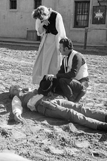
Four officers of the Los Angeles Police Department (Stacey Koon, Laurence Powell, Timothy Wind, and Theodore Briseno) were accused of using unnecessary force in a March 3, 1991, beating of an African-American motorist Rodney Glen King.
[41] Due to the heavy media coverage of the arrest, Judge Stanley Weisberg of the California Court of Appeals approved a change of venue to neighboring Ventura County, using an available courtroom in Simi Valley for the state case against the officers.
Many believed that the unexpected outcome was a result of the racial and social make-up of the jury, which included ten white people, one Filipino person, and one Hispanic woman.
[50] Simi Valley has been the victim of several natural disasters, including the flood of 1967, the storm of 1983, the 1988 lightning strike, as well as the 1994 Northridge earthquake and numerous wildfires.
More than 1,000 firefighters worked against the tricky combination of dry brush, low humidity and temperatures in the high 90s along the line that divides Los Angeles and Ventura counties.
However, the housing boom in the 1960s and 1970s attracted many white Americans leaving urban areas in Los Angeles and the San Fernando Valley.
Hispanic or Latino of any race were 10,938 persons (23.3%); 16.2% of Simi Valley's population were Mexican-American, 1.2% Salvadoran, 0.9% Guatemalan, 0.6% Puerto Rican, 0.6% Peruvian, 0.3% Cuban, 0.3% Argentine, 0.2% Honduran, 0.2% Nicaraguan, and 0.2% Ecuadorian.
The majority of Simi Valley's population was made up of Caucasian-Americans; the largest groups of whites were 16.7% German-American, 11.3% English, 8.5% Italian, 3.4% French, 3.1% Polish, 2.3% Norwegian, 2.3% Swedish, 2.1% Scottish and 2% Dutch.
This included a total of fifty parks, where some are urban city-parks, while others are public open space or multi-purpose trail systems.
[122] The city also boasts six golf courses and the Kanan Ranch home development has nature trails for hikers, bicyclists and horse riders to enjoy.
The west end of Simi Valley is also home to the 150-acre Tierra Rejada Park, which offers hiking trails to nearby Moorpark.
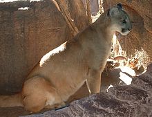
[127] The Simi's undeveloped native habitat provides routes that protect larger land wildlife of the Santa Monicas from genetic isolation.
[130] Birds in Simi Valley include Anna's hummingbird, Canada goose, mallard, California quail, common egret, great blue heron, American bittern, American coot, killdeer, mourning dove, roadrunner, belted kingfisher, black phoebe, barn swallow, cliff swallow, common raven, crow, white-breasted nuthatch, cactus wren, mockingbird, robin, cedar waxwing, phainopepla, starling, least Bell's vireo, hooded oriole, western tanager, several species of blackbird (western meadowlark, Brewer's blackbird and brown-headed cowbird) and woodpeckers (common flicker, Nuttall's woodpecker, acorn woodpecker, and yellow-bellied sapsucker).