Skellig Michael
The island is named after the archangel Michael, with "Skellig" derived from the Irish language word sceilig, meaning a splinter of stone.
Skellig Michael consists of approximately 22 hectares (54 acres) of rock, with its highest point, known as the Spit, 218 m (714 ft) above sea level.
The island is defined by its twin peaks and intervening valley (known as Christ's Saddle), which make its landscape steep and inhospitable.
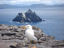
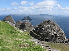
It is best known for its Gaelic monastery, founded between the 6th and 8th centuries, and its variety of inhabiting species, which include gannets, puffins, a colony of razorbills and a population of approximately fifty grey seals.
According to legend, Irr, son of Míl Espáine (who is sometimes credited with the colonisation of Ireland), was travelling from the Iberian Peninsula, but drowned and was buried on the island.
[7] Daire Domhain ("King of the World") is said to have stayed there c. 200 AD before attacking Fionn mac Cumhaill's army in nearby Ventry.
[8] Other early mentions include in the narrative prose of the Lebor Gabála Érenn and Cath Finntrágha, as well the medieval Martyrology of Tallaght.
[9] Skellig Michael is a steep pyramidal rugged rock (or "crag")[10] of c. 18 ha (45 acres) on the Atlantic coast off the Iveragh peninsula of County Kerry.
[1][11] The region's topography of peaks and valleys are characterised by steep ridges formed during the Hercynian period of folding and mountain formation some 300 million years ago.
[1] When the Atlantic ocean level rose, it created deep marine inlets such as Bantry Bay and left the Skelligs detached from the mainland.
[10] The Wailing Woman rock lies in the centre of the island, on the ascent before the Christ's Saddle ridge,[12] 120 m (400 ft) above sea level, on 1.2 ha (3 acres) of grassland.
Further up is the Stone of Pain area, including the station known as the Spit, a long and narrow fragment of rock approached by 60-centimetre-wide (2 ft) steps.
Noting the inaccessibility of the island, writer Des Lavelle observes that "the fact that the monks of old undertook the giant task of constructing a stairway to this bleak cove is a good argument that the weather conditions then were far better than now.
[11] Nonetheless, it has an ecology far more diverse than on the mainland; as an island, it provides sanctuary to wide varieties of flora and fauna, many of which are unusual to Ireland.
[25] Many of the islands off the south-west coast of Ireland have early Christian monasteries; the region was favoured because of its isolation and the abundance of rock for building.
[31] Theories for the site's abandonment include that the climate around Skellig Michael became colder and more prone to storms, Viking raids,[32] and changes to the structure of the Irish Church.
[35] Skellig Michael remained in the possession of the Catholic Canons Regular until the dissolution of Ballinskelligs Abbey in 1578, a result of the reformation by Elizabeth I.
[2][36] Ownership of the islands passed to the Butler family (for rental of "two hawks and a quantity of puffin feathers yearly"),[37] with whom it stayed until the early 1820s when the Corporation for Preserving and Improving the Port of Dublin (predecessor to the Commissioners of Irish Lights) purchased the island for £500[38] from John Butler of Waterville in a compulsory purchase order.
[17] The Office of Public Works took the remains of the monastery into guardianship in 1880, before purchasing the island (with the exception of the lighthouses and associated structures) from the Commissioners of Irish Lights.
The larger is positioned between Saint Michael's Church and the main Oratory,[47] and is thought to pre-date both, and once had a large upright cross at its western end, which is now broken off.
[53] The eroding effect of frost on the island's major fault line provided the masons with large amounts of materials for the construction.
[56] Wondering why such an inaccessible and harsh outpost might have been built, the historian Walter Horn wrote that "the goal of an ascetic was not comfort" and recalled that the Cambrai Homily states: "This is our denial of ourselves, if we do not indulge our desires and if we abjure our sins.
[55][58] Archaeological evidence shows that basal sections of each series of steps were rock-cut, giving way to more stable dry stone masonry once they reached an altitude where the sea waves would no longer weather them.
[18] The lower part of the east steps above Blind Man's Cove was heavily blasted with dynamite in 1820 during the construction of the pier and Lighthouse Road, and are now inaccessible from the landing point.
[59] The steps above this level, on a very steep climb along a sheer face,[17] have been subject to conservation, most recently in 2002/2003 when large amounts of overgrowth were removed,[17] and are today in good condition.
He observed that "looking back from the great civilizations of twelfth-century France or seventeenth-century Rome, it is hard to believe, that for quite a long time—almost a hundred years—western Christianity survived by clinging to places like Skellig Michael, a pinnacle of rock eighteen miles from the Irish coast, rising 700 feet [210 m] out of the sea".
By 1990, the level of demand had grown to the extent that the Office of Public Works began to organise ten boats departing from four individual harbours.
[65] Each year at least four boat licences are granted to tour operators[66] who run trips to Skellig Michael during the summer season (May to October, inclusive), weather permitting.
When such large wave troughs recede, they can often expose ragged seaweed stumps, sponges and anemones on the rock faces, further hampering approach and landing.
[67] According to some reports, climate change in the form of increased rainfall, sea swells and more severe storms has threatened Skellig Michael, with tourism likely to be affected by these factors.