Skullyville County, Choctaw Nation
Skullyville County was a political subdivision of the Choctaw Nation of Indian Territory, prior to Oklahoma being admitted as a state.
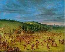
The village which grew up around the agency came to be known as Skullyville, that word being a corruption of iskulli with the suffix, -ville, suggesting a literal translation of money town.
[3] Fort Coffee was built and garrisoned by the U.S. Army in 1834 to secure the region from incursions by the "wild" Wichita and Comanche Indians to the west.
The county's southern border threaded its way through well-defined valleys along Cavanal Mountain and adjacent ridges, following Cedar Creek, Fourche Maline, and the Poteau River.
Constitutional officers, all of whom served for two-year terms and were elected by the voters, included the county judge, sheriff, and a ranger.
The sheriff collected taxes, monitored unlawful intrusion by intruders (usually white Americans from the United States), and conducted the census.
While this was not generally true of Skullyville County, with its bustling commercial towns along several railroad lines, and particularly Poteau, it would have to be dismantled to accommodate changes required by the region at large.