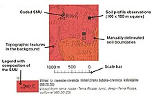
Soil map
Soil maps are most commonly used for land evaluation, spatial planning, agricultural extension, environmental protection and similar projects.
Soil maps produced using (geo)statistical technique can also include an estimate of the model uncertainty.
A SIS is in the most cases, a combination of polygon and point maps linked with attribute tables for profile observations, soil mapping units and soil classes.
Different elements of an SIS can be manipulated and then visualized against the spatial reference (grids or polygons).
[4] In the case of pedometric mapping, both predictions and simulations (2D or 3D — geographic location plus soil depth) of values are visualized and used for GIS modeling.