South End, Boston
The South End is a neighborhood in Boston, Massachusetts, United States which is bordered by Back Bay, Chinatown, and Roxbury.
The South End is the largest intact Victorian row-house district in the country, covering over 300 acres (120 ha).
It is home to diverse groups, including immigrants, young families and professionals, and it is popular with Boston's gay and lesbian community.
[3] The South End has been characterized by diversity since the 1880s, with substantial Irish, Jewish, African-American, Puerto Rican (in the San Juan Street area), Chinese, Italian, and Greek populations.
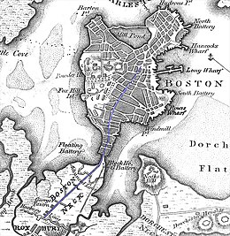
Land belonging to the South End has been part of the city of Boston since its founding, although it was smaller when first settled and surrounded by large tidal flats.
[5] Nineteenth-century technology did not allow driving steel piles into bedrock, and a system of submerged timbers provided an understructure for most South End buildings.
[6][7] Groundwater levels in Boston had been dropping for years by 2006, damaging some wood pilings by exposing them to air.
Middle-class people moved to the South End, including business owners, two mayors, bankers, and industrialists, but the neighborhood's wealthy status was relatively short-lived.
By the close of the nineteenth century, the South End was becoming a tenement district; it attracted immigrants and, during the 1940s, gay men.
The largest concentration of Pullman porters in the country lived in the South End, primarily between Columbus Avenue and the railroad.
[2] The hospital used fresh-air cures and home remedies on patients, and surgical cases were sent to the Boston University School of Medicine.
[2] Although City Hospital admitted Black patients, they were not allowed in their training programs or hired as professionals.
[2] Cornelius Garland, a Black physician from Alabama, opened Plymouth Hospital and Nurse's Training School by 1908.
[22] It was redeveloped as a mixed-use area known as the Ink Block, with apartments, a grocery store, restaurants, and other retail businesses.
[2] Albany Street, along the Roxbury Canal, became occupied by warehouses and factories and was the center of Boston's furniture and piano-making industry by the 19th century.
Its offices were originally above Charlie's Sandwich Shoppe (whose walls are lined with photographs of jazz musicians who ate there), but moved to 409 Massachusetts Avenue around 1930.
[26] The Josiah Quincy Upper School teaches grades six to 12, balancing core-subject requirements with world languages, the arts and physical education.
[28] Benjamin Franklin Institute of Technology, established in 1908, is a four-year South End school for students desiring a technical degree.
[29] Programs for adults include monthly book-discussion groups and a weekly English conversation class.
[30] Services include adult medicine, behavioral health, dental care and nutrition to name a few.
The Animal Rescue League of Boston, founded in 1899 by Anna Harris Smith, is at 10 Chandler Street.
The South End's population has been diverse since the 1880s when Irish, Lebanese, Jewish, African-American, Puerto rican, Italian, and Greek people began to settle in the neighborhood.
A number of immigrants from Canada's maritime provinces found economic opportunity in Boston, and homes in the South End, during the 1930s.
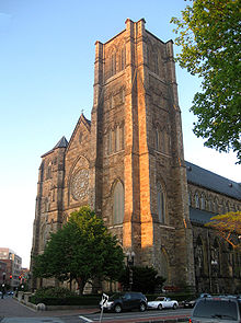
Late in the decade, the Hispanic population began to grow; at first, much of this settlement was centered around the Cathedral of the Holy Cross.
Although gentrification is sometimes cited as a reason for the flight of poorer, non-white residents, the neighborhood has maintained racial and income diversity due to its subsidized, publicly owned, or otherwise low-income housing units and a homeless shelter.
The South End is known as an increasingly upper middle class neighborhood, although it is still home to many lower income residents.
GardenMoms, one of Boston's most popular online parent groups with over 2,500 members citywide, was founded by several South End mothers in 2002.