South Ferry/Whitehall Street station
In the early 2000s, as part of the recovery effort from the September 11, 2001, attacks, a new South Ferry terminal for the Broadway–Seventh Avenue Line was proposed.
[3]: 21 However, development of what would become the city's first subway line did not start until 1894, when the New York State Legislature authorized the Rapid Transit Act.
[9]: 102 Contractors installed a waterproof membrane and operated pumps continuously to prevent the loop from being inundated by water from New York Harbor.
Because Battery Park had been created largely through land reclamation, workers found skulls, copper coins, logs, and remnants of brick piers when they were excavating the station's site.
[14] To address overcrowding, in 1909, the New York Public Service Commission proposed lengthening platforms at stations along the original IRT subway.
[15]: 168 As part of a modification to the IRT's construction contracts, made on January 18, 1910, the company was to lengthen station platforms to accommodate ten-car express and six-car local trains.
[15]: 168 [17] The Dual Contracts were formalized in March 1913, specifying new lines or expansions to be built by the IRT and the Brooklyn Rapid Transit Company (BRT).
[19] It was predicted that the subway extension would lead to the growth of the Lower West Side, and to neighborhoods such as Chelsea and Greenwich Village.
[19] Before the Dual Contracts were signed, the Public Service Commission had tentatively planned a subway line under Seventh Avenue.
[38] The BRT attributed the delays to "inadequate turnback facilities" at Whitehall Street and, in August 1918, announced that they would revise the track configuration of the station.
[40][41] An additional entrance at the southern end of the station opened in November 1919, providing a direct connection to the Whitehall Terminal of the Staten Island Ferry.
[50][51] On September 11, 2001, a terrorist attack destroyed the World Trade Center, located slightly to the north of South Ferry and the Battery.
[56] New York governor George Pataki presented plans in February 2003 for a $400 million South Ferry terminal with three tracks and two platforms.
[59]: 69 The station was originally budgeted at $400 million, most of which came from a Federal Transit Administration grant that had been earmarked for the World Trade Center's reconstruction.
[60] Initially, neighborhood groups opposed the station's construction because of the high cost and low perceived time savings.
[62] Community leaders acquiesced after being told that some of the money was going to be used to renovate Battery Park,[63] and the South Ferry Terminal Project was allowed to proceed.
[65][66] Silver eventually agreed to drop his opposition if funding was provided for Battery Park's renovation, and federal, state, and city officials reached an agreement in June 2004.
[94] The MTA initially did not consider reopening the old IRT outer loop, saying that it no longer owned the station, that the platform was inaccessible, and that the only exits had been "halved to allow for an employee facility".
[111] After the Joralemon Street Tunnel opened in 1908, some trains continued to terminate at South Ferry during rush hours, while others went to Brooklyn.
[142][143] In addition, weekday W trains to Ditmars Boulevard used the Whitehall Street station as their southern terminus[142][143] until that route was discontinued in June 2010.
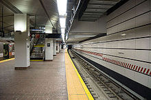
[148]: 7.43 The two sections are connected via a shared fare control area near the south end of the station, which is accessed via stairs in Peter Minuit Plaza and on the eastern side of Whitehall Street.
The South Ferry portion of the complex is under Battery Park, which is almost entirely built atop reclaimed land; this site historically contained the Kapsee rocks.
[9]: 103 The outer platform was smaller than most others in the system, having only 16,800 square feet (1,560 m2) of surface area, and it was originally served from two stairs leading from the Staten Island Ferry's Whitehall Terminal.
[60][52]: 1·5 (PDF p. 5) [56] In addition, spray nozzles were required to lubricate the track to reduce the friction caused by the tight curve, which slowed train operation and generates a loud metallic scraping noise.
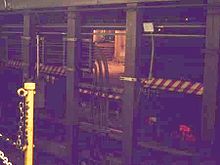
[60][52]: 1·5 (PDF p. 5) The gap fillers, which were automated when the station closed in 2017, previously required manual operation, with a foreman and at least two train crew, all of whom could directly see each other.
The train crew had to give a signal to the foreman, who pulled a 4 to 5 feet (1.2 to 1.5 m) tall wooden lever to manually extend and retract the gap fillers.
[120] There are also fifteen ceramic plaques toward the top of the platform wall, all of which depict a sloop in the New York Harbor to signify the station's location and use.
The station artwork on the original exit's landing is a 1990 mural, "South Sails", by former MTA Arts & Design director Sandra Bloodworth.
"[73] The station's mezzanine and escalator shafts feature an artwork titled See it split, see it change, which consists of fused glass wall, stone mosaic, and a stainless steel fence.
The outer tracks, used by daytime R and nighttime N trains, continue south into the Montague Street Tunnel to the BMT Fourth Avenue Line in Brooklyn.