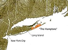
South Fork (Long Island)
This name is also used to name a trail that navigates the entirety of the South Fork (as well as parts of Long Island), the Paumanok Path.
The eastern end of the South Fork, Montauk Point State Park, in the census-designated place of Montauk, New York, is the easternmost point in the State of New York, and of Suffolk County.
The most prominent road on the south fork is Montauk Highway (part of New York State Route 27) which traverses the entire region.
For example, Noyac Road provides a parallel route to Montauk Highway in the northern area of the region between North Sea and Sag Harbor.
Additionally, passenger ferry service runs occasionally between Montauk and Block Island, RI, New London, CT, and Martha's Vineyard, MA.