South Fork Eel River
The South Fork drains a long and narrow portion of the Coast Range of California in parts of Mendocino and Humboldt counties.
In the 1920s, a private company built the Benbow Dam, blocking fish migration to a large area of the basin.
The South Fork Eel River begins near Iron Mountain in western Mendocino County, at an elevation of 2,500 feet (760 m).
Dropping off the high plateau where it begins, the South Fork winds north and bends southwest through a steep and narrow canyon.
[6] It is not long after its headwaters that Branscomb Road drops into the South Fork Eel's canyon from the north, paralleling the river.
Although it is not a large creek, only about 2.5 miles (4.0 km) long,[7] it denotes the start of the National Wild and Scenic River section of the South Fork.
Tenmile Creek begins in another section of the Coast Range, separated from the South Fork Eel River by two sub-ranges.
It then meanders north into Richardson Grove State Park on an increasingly wide valley floor, receiving Red Mountain Creek on the right bank.
[13] After passing through the Benbow Dam, which is non-functional during the winter months, the South Fork Eel receives another tributary called Redwood Creek on the left bank, as it bends north and then west around the community of Redway, California, which is located on a plateau east of the river.
Several hundred yards upstream from its confluence, it receives its last major tributary, Bull Creek, on the left bank.
Meandering through a downcut channel between U.S. 101 and SR 254 (right bank) and California State Route 211, it then crosses under the former two highways, spreads wider, and flows into the Eel River.
Although U.S. Highway 101 and California State Route 271 follow the river for over 70 percent of its length, there are few communities in the steep and narrow, forested canyon of the South Fork.
Towns along the river include Branscomb, Underwood Park, Leggett, Piercy, Andersonia, Benbow, Garberville, Redway, Phillipsville, Miranda, Myers Flat, and Weott.
Historic logging activity in the South Fork watershed has stripped steep hillsides bare of vegetation, resulting in chronic erosion problems.
Historically, South Fork Eel River water had an unusual translucent blue-green hue for most of the year.
The rugged topography of the South Fork Eel River watershed also produces an amount of waterfalls from tributary streams.
Although there are no large waterfalls on the South Fork or its major tributaries, there are many on smaller side streams, especially after heavy rainfall.
A higher peak flow of 78,700 cubic feet per second (2,230 m3/s), on 22 December 1964, before the stream gauge was in place, was determined using flood stage height data and floodmark measurements.
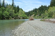
[28] In much of the middle and lower course of the South Fork Eel, the riverbed is mostly bare gravel, with sparse vegetation, and without a floodplain.
[28] Prior to white settlement of Central California, much of the Eel River watershed was inhabited by Pomo Indians and Athapascan peoples.
The stagnant water in the lake was heated by the sun to a higher temperature than normal and severely hurt salmon and steelhead runs, as well as other aquatic and migratory life downstream.
[32] Dam decommissioning will start to occur on the Klamath River in 2022 pending Federal Energy Regulatory Committee (FERC) approval.
[35] Several tributaries, such as Hollow Tree Creek, also support anadromous fish, but they have become impaired in ways similar to the South Fork Eel.