Harris, Outer Hebrides
[2] Documents from several centuries ago show the Isle of Harris being referred to as Haray or Harray, Here or Herre, Herrie, and the plural Harreis; as well as possibly related place names such as Harris on the isle of Rum; Herries in Dumfries; Harray on Orkney; and Harrastadhir (Harrastaðir) in Iceland.
[3] The place-name Harris has been suggested to be based on Old Norse hærri, meaning 'higher', a reference to the high hills, especially in comparison with the much flatter Lewis lying to the north.
[citation needed] Harris is most likely to be the island referred to as Adru (meaning 'thick, stout or bulky') on Ptolemy's map of the British Isles.
[9] North Harris, adjoining Lewis, contains Clisham (An Cliseam), the highest mountain in the Outer Hebrides at 799 metres (2,621 ft).
[16] In 2008 Mike Russell, the Scottish environment minister announced that the North Harris Trust had begun canvassing local opinion about a proposal to create Scotland's third national park in the area.
[17] The southern part of Harris is less mountainous, with numerous unspoilt, white sandy beaches on the west coast.
A ferry sails from the latter to Berneray (Beàrnaraigh na Hearadh), an island off the coast of North Uist (Uibhist a Tuath), to which it is joined by a causeway.
From Stockinish the road is the Bays and meanders through the coastal townships of Lickisto (Liceasto), Geocrab (Geòcrab), Manish (Mànais), Flodabay (Fleòideabhagh), Quidinish (Cuidhtinis), Finsbay (Fionnsbhagh) and Lingerbay (Lingreabhagh).
His books: Crowdie and Cream, Crotal and White and The Corncrake and the Lysander paint a vivid and humorous picture of Hebridean life.
Local fishermen have been targeting large Common Skate in the area and have had prolific catches, mainly from West Loch Tarbert, in autumn and winter.
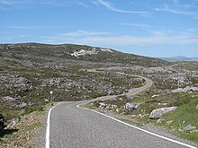
[18][19] In common with many parts of the Highlands and Islands, Harris has numerous single-track roads with passing places at intervals.
Every length of cloth produced is stamped with the official Orb symbol, trademarked by the Harris Tweed Association in 1909.
[31] This area has been described as the last bastion of Reformed fundamentalism in the UK, and there was controversy in 2006 when Caledonian MacBrayne started a Sunday ferry service.
[32] However, a Sunday ferry service between Berneray (North Uist) and Leverburgh (An t-Òb) in the south of Harris has been introduced with relatively little controversy and now operates all year round.
[33] In his 1962 novel Atlantic Fury Hammond Innes put a fictional Joint Services Guided Weapons Establishment in Northton, South Harris, where some of the action takes place.
A group of sixth-year pupils at the Sir E. Scott secondary school in Tarbert won the 2003 Young Enterprise UK Award for their design, marketing, and selling of the Isle of Harris district tartan.