Islands of the Clyde
The geology and geomorphology of the area is complex, and the islands and the surrounding sea lochs each have distinctive features.
They come to Arran to study its intrusive igneous landforms, such as sills and dykes, as well as its sedimentary and metasedimentary rocks, which range widely in age.
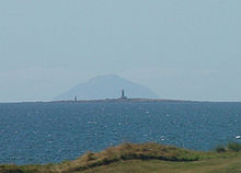
[10] Ailsa Craig, which lies some 25 kilometres (16 mi) south of Arran, has been quarried for a rare type of micro-granite containing riebeckite, known as "Ailsite".
[13] Sea-level changes and the isostatic rise of land after the last retreat of the ice created clifflines behind raised beaches, which are a prominent feature of the entire coastline.
Elsewhere, especially to the south and west, there are raised beach- and marine deposits, which in some places, such as Stravanan, result in a machair landscape inland from the sandy bays.
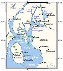
[16][17] The Firth of Clyde, in which these islands lie, is north of the Irish Sea and has numerous branching inlets.
May, June and July are the sunniest months: on average, there is a total of 200 hours of bright sunshine during that 3-month period each year.
In fact, there is some evidence that the Firth of Clyde was a significant route through which mainland Scotland was colonised during the Neolithic period.
It is thought likely that the Clyde cairns were the earliest forms of Neolithic monument constructed by incoming settlers.
Known today as the “Queen of the Inch necklace,” it is an article of jewellery made of lignite (commonly called “jet”).
Unlike earlier inhabitants, such as the P-Celtic speaking Brythons, these Gaels spoke a form of Gaelic (a modern version of which is still spoken today in the Hebrides).
[30] Islands close to the shores of modern Ayrshire presumably remained part of the Kingdom of Strathclyde during this period, whilst the main islands became part of the emerging Kingdom of Alba founded by Kenneth MacAlpin (Cináed mac Ailpín).
Beginning in the last half of the 12th century, and then into the early 1200s, the islands may well have served as the power base of Somhairle mac Giolla Brighde and his descendants.
[31] This western extension of Scottish authority appears to have been one of the factors motivating the Norwegian invasion of the region in 1230, during which the invaders seized Rothesay Castle.
Haakon retreated to Orkney, where he died in December 1263, consoled on his death bed by recitations of the old sagas.
Following his death, under the 1266 Treaty of Perth, all rights that the Norwegian Crown "had of old therein" in relation to the islands were yielded to the Kingdom of Scotland.
[35][36][37] Politically, from the conclusion of the Treaty of Perth in 1266 to the present day, all of the islands of the Clyde have been part of Scotland.
New forms of transport, industry, and agriculture brought an end to ways of life that had endured for centuries.
[39] In the late 18th and early 19th centuries, Alexander, the 10th Duke of Hamilton (1767–1852), and others implemented a controversial agricultural-reform programme called the Highland Clearances that had a devastating effect on many of Arran's inhabitants.
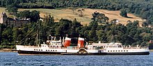
)[40][41][42][43] From the 1850s to the late 20th century, cargo ships known as “Clyde Puffers” (made famous by an early-20th-century story collection called the Vital Spark), were the workhorses of the islands, carrying a great deal of produce and a great variety of products to and from the islands.
[44] David MacBrayne operated the Glasgow-to-Ardrishaig steamer service, as part of the so-called "Royal Route" to Oban.
[48] A government-owned corporation, they serve Great Cumbrae, Arran, and Bute, and also run mainland-to-mainland ferries across the firth.
[4][49] Private companies operate services from Arran to Holy Isle,[5] and from McInroy's Point (Gourock) to Hunter's Quay on the Cowal peninsula.
Since the 1975 reorganization, however, the islands have been split more or less equally between two modern council authorities: Argyll and Bute, and North Ayrshire.
Only Ailsa Craig and Lady Isle in South Ayrshire are not part of either of these two council areas.
Below is a table listing the nine islands of the Firth of Clyde that have an area greater than 40 hectares (approximately 100 acres), showing their population and listing the smaller uninhabited islets adjacent to them (including tidal islets separated only when the tide is higher, and skerries exposed only when the tide is lower).
Gare Loch is small, but it hosts the Faslane Naval Base, where the UK's Trident nuclear submarines are located.
In the late 11th century, a king of Norway (Magnus Barefoot) devised a plan to increase his territorial possessions.
[74] Over 200 bird species have been recorded as sighted in the area, including the black guillemot, the eider, the peregrine falcon, and the golden eagle.
The name literally means "wash", probably referring to a river goddess who is seen as "the washer" or "the strongly flowing one".