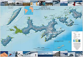
South Shetland Islands
They lie about 120 kilometres (65 nautical miles) north of the Antarctic Peninsula,[1] and between 430 and 900 km (230 and 485 nmi) southwest of the nearest point of the South Orkney Islands.
[4][5] In 1818, Juan Pedro de Aguirre obtained permission from the Buenos Aires authorities to establish a base for sealing on "some of the uninhabited islands near the South Pole".
Smith revisited the South Shetlands, landed on King George Island on 16 October 1819, and claimed possession for Britain.
The crew of San Telmo and the troops onboard, led by Brigadier Rosendo Porlier (a total of 644 men), are believed to be the first known humans to land in Antarctica.
[7] From December 1819 to January 1820, the islands were surveyed and mapped by Lieutenant Edward Bransfield on board the Williams, which had been chartered by the Royal Navy.
The first sealing ship to operate in the area was the brig Espirito Santo, chartered by British merchants in Buenos Aires.
A narrative of the events was published by the brig's master, Joseph Herring, in the July 1820 edition of the Imperial Magazine.
The Espirito Santo was followed from the Falkland Islands by the American brig Hersilia, commanded by Captain James Sheffield (with second mate Nathaniel Palmer), the first US sealer in the South Shetlands.
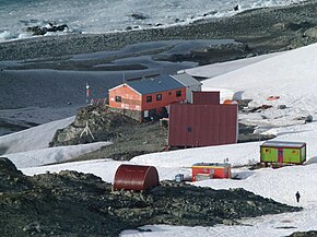
The archipelago, together with the nearby Antarctic Peninsula and South Georgia Island, is an increasingly popular tourist destination during the southern summer.
The South Shetlands consist of 11 major islands and several minor ones, totalling 3,687 km2 (1,424 sq mi) of land area.
[12] Quaternary volcanic products of the islands tend to have less potassium and sodium at a given silica range, and lower Nb/Y ratios, than those associated with the Larsen Rift on the Antarctic Peninisula.
The islands have experienced measurable glacier retreat during recent years, but despite this, they remain more than 80% snow- and ice-covered throughout the summer.
These areas support tundra vegetation consisting of mosses, lichens, and algae, while seabirds, penguins, and seals feed in the surrounding waters.