South Willingham
A Royal Observer Corps nuclear monitoring post was installed in the bowl barrow on the High Street, close to the junction with the Donington Road in 1959.
South Willingham is recorded in the Domesday Book as "Ulingeham", in the hundred of Wraggoe, and contained three manors owned by different lords.
The first contained 11 villagers and two smallholders, with four ploughlands, 2.5 lord's and 2 men's plough teams, and a meadow of 77 acres (31 ha).
The second contained four villagers and one smallholder, with 1.6 ploughlands, one lord's and one men's plough team, and a meadow of 36 acres (15 ha).
[7][8][9] South Willingham's Anglican parish church is dedicated to St Martin, and dates from the early 13th century.
[13][15][16][17] The remaining children transferred to the school in Hainton, the South Willingham building since converted to a residence.
Benniworth Windmill was located 120 yards (110 m) from the eastern parish boundary and close to Donington on Bain.
South Willingham parish council is the lowest tier of local government, responsible for services including allotments, cemeteries, play areas, street furniture and neighbourhood development plans.
The parish is in the Binbrook Ward which covers ten local parishes and sends one councillor to the East Lindsey District Council, the next highest tier of government, which is responsible for services including economic, business and tourism support, housing benefits, collection of local taxes, refuse, planning and environmental control, licensing, and leisure facilities.
Above this, the parish is represented by one councillor for the Louth Wolds Division of Lincolnshire County Council, the council provision including highway maintenance, social care, libraries, heritage sites, school admissions, trading standards, fire and rescue, emergency planning, and public health.
Prior to Brexit in 2020, South Willingham was represented in the European Parliament through the East Midlands constituency.
The civil parish is 3.5 miles (6 km) east to west and 1.75 miles (3 km) north to south, covering 2,043 acres (827 ha)—expanded from 1,900 acres (769 ha) in the 1880s—and is on the western edge of the Lincolnshire Wolds, an Area of Outstanding Natural Beauty (AOB).
Continuing east, the other side of the High Street, is the glacial valley of the River Bain (69m AOD).
Rain falling to the east of the High Street drains into the River Bain, which runs south via Horncastle and into the Witham at Dogdyke.
From west to east, the bedrock changes from Kimmeridge Clay to Spilsby Sandstone to Claxby Ironstone to Tealby Mudstone, covered in places with superficial deposits of sand and gravel.
In 2013, exploratory oil wells were proposed in the River Bain valley at Biscathorpe, 700m north east of the parish boundary.
[32] According to the 2011 census, the population of South Willingham Civil Parish totals 160 people (86 men and 74 women) in 78 households.
The various censuses show that the population of South Willingham increased rapidly in the early 19th century and peaked in the 1850s at 341.
Census records between 1841 and 1891 show that up to seven people were occupied making bricks and tiles, reducing to one person in 1891.
Piper Sports Cars were manufactured by Emmbrook Engineering from a large brick and asbestos industrial shed in the railway station yard.
The kit cars used fiberglass bodies with Triumph and Ford components and were made in the village between June 1973 and the mid-1970s.
At the end of 2019 these included photographer, accountant, architect, stone mason, decorator, Dog breeder and groomer, training consultancy and a company selling parquet flooring.
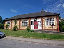
South Willingham Parish Hall was gifted to the village in 1922 by Lord Heneage, according to the plaque at its entrance.
The hall is used for social and public events, and meetings, such as coffee mornings and film nights, and groups for art, dance, and history.
Wells and pumps in the village extracted water from the underlying Kimmeridge Clay which includes layers of shale and ironstone.
South Willingham is connected to the Burgh on Bain telephone exchange—part of the Louth/Alford/Spilsby 01507 dialling code—on the A157 and High Street junction.
South Willingham's Anglican parish church is dedicated to St Martin, and is Grade II* listed.
A prehistoric trackway, later adopted by the Romans,[54] now the B1225 road, running north–south along the western edge of the Wolds from Caistor to Baumber passes through the eastern half of the parish, and a mile away from the village.
It is used by the Stagecoach Lincolnshire number 50 Louth to Lincoln bus service which has 6 buses daily in each direction.
Two further demand responsive services are provided for the parish by Lincolnshire InterConnect, with connection to villages between and around Louth, Market Rasen and Wragby.