Southern Lakes (New Zealand)
Despite being an unofficial designation, the term Southern Lakes is sometimes used by organisations such as the New Zealand Meteorological Service [1] and Automobile Association.
[2] Though exact definitions vary, the area encompasses parts of western Southland (including Fiordland) and Central Otago, and is occasionally extended to include the Mackenzie Basin of inland Canterbury, a total of roughly 28,000 to 35,000 square kilometres (11,000 to 14,000 sq mi).
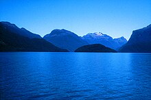
Much of the scenery was heavily glaciated during the last ice age, and as such contains many broad U-shaped valleys, several of which are filled with large lakes.
The northern group of Mackenzie Basin lakes form part of the Waitaki River system.
The areas main centres of population are Queenstown and Wānaka in Otago, and Te Anau in Southland.