Clutha River
Rivers and valleys were the main transport system used by local Māori to access the interior of the South Island.
It has a mean discharge of approximately 500 m3 (18,000 cu ft) and a catchment area of around 22,000 km2 (8,500 sq mi) and is an economically significant river for the country.
The Clutha River drains the high mountains of the Southern Alps in the west and passes through a complex topographic system of basins and ranges towards the east before reaching into the Pacific Ocean.
A majority of the topographical features of the Clutha River catchment area are a direct result of the late Cenozoic and active tectonic processes that are occurring in southern South Island due to deformation along the nearby plate boundary, defined by the Alpine Fault.
[16][17] By the end of the fourteenth century, the environment in Otago and Southland (Murihuku) had begun to shift, with podocarp woods retreating and the moa population declining.
Kāi Tahu used to travel in to the interior of the South Island almost every year and had campsites and burial sites along the Clutha River and its nearby lakes.
[20] The mouth of Mata-au was heavily populated, with many permanent and temporary Kāi Tahu settlements throughout the lower stretches of the river.
[21][22] Māori trading groups used the Cromwell Gorge as the main thoroughfare to their pounamu and moa-hunting expeditions to the interior of Otago.
[24] During early European settlement in the South Island, a whaling station was established close to the Clutha River's mouth at Port Molyneux, and during this period the sea was the source of almost all of the area's economy.
[25] The first European to visit the Upper Clutha area and to see the inland lakes of Wakatipu, Wānaka and Hāwea was Nathanael Chalmers, who was guided by Chiefs Reko and Kaikōura in 1853.
[23] Alexander and Watson Shennan set off from Milton (known previously as Tokomairiro) in December 1857 to Central Otago, looking for land to raise sheep.
[33][34] In 1862, gold-rich bars of rocks and gravel were discovered by Christopher Reilly and Horatio Hartley during their winter 1862 expedition up Cromwell Gorge through the waters of the Clutha.
With several settlements quickly established along gold-rich rivers such as the Clutha and Kawarau, the rush to Central Otago was the largest in the region's history.
[37] Around 100 dredges have operated at various times during the area's history in the river bed and nearby gravels, including the present-day gorge to the east of the Old Man Range.
A Middle Pleistocene-age ancestral Clutha River delivered detrital gold across the lower parts of what is presently the Manuherikia Valley near Alexandra.
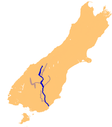
[4][44] The Clutha River extends about 340 km (210 mi), flowing roughly north to south through the Otago Region.
Located at a maximum elevation of approximately 2,800 m (9,200 ft) on the Main Divide of the Southern Alps, the majority of the river's headwater flows originate from the melting of alpine snow cover and rainfall, with glaciers contributing a minor amount.
The contribution of snowmelt to the annual streamflow of the Clutha River is estimated to be 10% by the time it reaches the Southern Pacific Ocean.
A number of large tributaries originate in Central Otago's semi-arid basins, where yearly precipitation can be as low as 400 mm (16 in), which is an order of magnitude lower than on the Main Divide.
This heavy flow, combined with the relatively small size of the river in global terms, makes the Clutha notoriously fast-flowing.
The study emphasises the importance of the genome-wide methods to identify species and understand biodiversity in freshwater ecosystems and conservation in the Clutha River.
[52] Before the construction of Roxburgh Dam, salmon could be found traversing the length of the Clutha River and spawning as far upstream as Lakes Hāwea and Wānaka.
The small settlement of Kelso on the banks of the Pomahaka River was completely abandoned and was not rebuilt once the waters subsided.
[65][66] The Clyde Dam was one of Robert Muldoon's and the Third National Government's "Think Big" projects, an interventionist state economic strategy.
[67][68] Several Local Authorities along the Clutha River use it as a source for treatment plants to provide communities with potable water.
[69][70] The Clutha provides irrigation for stone fruit orchards and vineyards around Cromwell, Alexandra, and Roxburgh, which grow apples, apricots, nectarines, cherries, peaches and grapes.