Southern Leyte
In September 2017, Representative Roger Mercado authored House Bill 6408, proposing to change the name of the province to Leyte del Sur.
As early as 1898 during the Spanish and American periods, there existed a "sub-province" consisting of the municipalities from Palompon to Hinunangan, with Maasin as the center.
There was also established in Maasin a Court of First Instance, then known as the Promoter Fiscal, where all minor administrative and other cases from Palompon to Hinunangan were heard.
This created a major problem because of the dearth of transportation, the difficulty in managing the affairs of government in Tacloban and the language barrier between the Cebuano-speaking South-westerners and the Waray-speaking North-easterners.
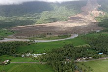
[12][13] On February 17, 2006, several mudslides caused by heavy rains, amounting over 200 cm (79 in), and a minor earthquake destroyed at least one town and many commercial and residential infrastructures, leaving hundreds dead.
The few handful of Guinsaugon citizens which escaped the mudslide were put up in emergency shelters without adequate nutrition and care despite the National Government collecting millions of dollars worth of donations.
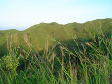
Southern Leyte is characterized by relatively flat lands along the coastal areas where population centers lie, but rugged mountains towards the interior.
It can be considered a braided river composed of several channels from near areas that divide and reunite forming an alluvial fan with a very wide floodplain.
[16] The river has overflowed, spilling its waters on the low-lying towns of Liloan and San Vicente and destroyed an ongoing flood control project worth millions of pesos.
Local officials blamed the rechannelization and uncontrolled quarrying of gravel and sand at the side of the river as the cause of the flood.
[19] At a meeting on March 18, 2002, one of the representatives of a government agency alleged that the reason of the incidents of flood and other environmental problems in the river was due to the "Philippine Fault" which caused rocks to rumble down.
[16] Along with other mountain forms in the province, Mount Nacolod in Hinunangan town has the highest peak with an elevation of 948 metres (3,110 ft) above sea level.
The major fault lines traverse the municipalities of Sogod, Libagon, Saint Bernard and San Juan to Panaon Island.
Based on Mines and Geosciences Bureau Region 8 data, these areas had experienced strong earthquakes in 1907 and 1948 with a magnitude of 6.9 and on July 5, 1984, with a 6.4 scale.
[9] The Mines and Geosciences Bureau warned that Southern Leyte's natural and geological features make it susceptible to landslides and floodings.
[20] The affiliated group stated that there are four contributory reasons: unusually heavy rains; numerous faults and badly broken rocks; steep slopes; and absence of effective vegetative cover.
Type II is characterized by the absence of dry season with a very pronounced maximum rain period occurring from November to January.
Inhabitants of the province plant rice, white corn, bananas, root crops, sugar cane, coconut and abacá.
The undertaking was to provide local residents educational opportunities to have knowledge on protecting the province's biodiversity as well as to have a long-term sustainability.
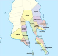
[9] After the inauguration of the province, three more municipalities were subsequently created: San Ricardo from Pintuyan, Tomas Oppus from Malitbog and Limasawa from Padre Burgos.
[26] In Panaon, an island situated in the southernmost part of the province, a certain aboriginal folk are found locally known as kongking or variously called mamanwa which means "mountain people".
[27] They were believed to be migrants from Mindanao, inhabiting the portions of Agusan, after their migration from the island to evade militarization and the logging/mining corporations’ intrusion to their ancestral domains in the early 1980s.
Hunting and gathering, mat weaving and rattan craft are among the main economic activities of the Mamanwas, so they prefer to inhabit the forested areas in the newfound Southern Leyte mountains.
Kinabalian, a type of "rare, unique language", is spoken alongside Cebuano in the towns of San Juan and Anahawan.
The first Holy Sacrifice of the Mass was held on March 31, 1521, led by Friar Pedro de Valderrama, the chaplain of Ferdinand Magellan during the expedition.
[30] Although most people are Christians, a very few who live in remote villages of the province hold on to pre-Hispanic influences and make offerings and sacrifices before planting their crops.
Farmers ritually sacrifice chickens and pigs to ensure that the spirits or elementals which they believe to be the cause of good harvest will grant them one.
Similarly, the historic and religious coming of the Spaniards is commemorated every March 31 in Limasawa with a cultural presentation and anniversary program dubbed "Sinugdan", meaning "beginning.
Most international travelers visit Southern Leyte for reef diving and snorkeling, from just outside Maasin City, all the way around Sogod Bay via Padre Burgos.
There are six designated bus terminals in Southern Leyte: Maasin, Liloan, Sogod, San Juan, Hinunangan and Silago.