Southern Zone Sea
The Sea of the Southern Zone (Spanish: Mar de la Zona Austral)[1] or Southern Zone Sea is the name given by Argentina and Chile to the maritime area whose boundaries were undefined, located south of the Isla Grande de Tierra del Fuego.
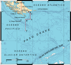
[3] The boundaries of the Sea of the Southern Zone have only been precisely defined in its northern part, where it reaches the shores of Isla de los Estados from its eastern extremity, the mouth of the Le Maire Strait, and the coast on the Isla Grande de Tierra del Fuego to the eastern mouth of the Beagle Channel at Cape San Pío.
On August 25, 1997, Chile signed and ratified the United Nations Convention on the Law of the Sea, and it entered into force for the country on September 24, 1997.
[28][29] In August of the same year, Chile made the oral presentations of both partial submissions during the 55th Session of the Commission on the Limits of the Continental Shelf at the United Nations in New York.
[30][5] In 2023, Chile, through SHOA, made available an illustrative graphic showing all the maritime areas claimed by the country, which was once again rejected by Argentina.