Chilean Antarctic Territory
Its boundaries are defined by Decree 1747, issued on November 6, 1940, and published on June 21, 1955,[3] by the Ministry of Foreign Affairs: The Chilean Antarctica or Chilean Antarctic Territory is: all lands, islands, islets, reefs, glaciers (pack-ice), and others, known and unknown, and respective territorial waters, existing within the limits of the cap constituted by the meridians 53° longitude west of Greenwich and 90° longitude west of Greenwich.The commune of Antártica has an area of 1,250,257.6 km2.
This treaty established that Antarctic activities are to be devoted exclusively to peaceful purposes by the signatories and acceding countries, thereby freezing territorial disputes and preventing the construction of new claims or the expansion of existing ones.
For many years, cartographers and European explorers speculated about the existence of the Terra Australis Incognita, a landmass potentially of vast size located south of the Strait of Magellan and Tierra del Fuego.
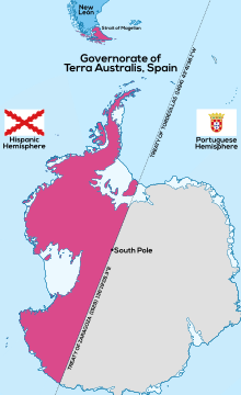
Though backed by the papal bull Ea quae pro bono pacis in 1506, the Treaty of Tordesillas was not recognized by several other European powers, including France and other Catholic states.
For England, the Netherlands, Russia and other countries, the Antarctic areas were considered res nullius, a no man's land, subject to the occupation of any nation that had the courage and ambition to send people to claim them.
In 1534, the Holy Roman Emperor Charles V divided the South American territory of Spain into three governorates: New Castile or Peru (to Francisco Pizarro), New Toledo or Chile (to Diego de Almagro) and New León (to Simón de Alcazaba y Sotomayor [es]) also known as the Magellanic Lands and subsequently extended to the Strait of Magellan.
[7][8][9] A Royal Decree of 1554 states: Because it was personally consulted, we will grant to the Captain Jeronimo de Alderete the land across the Magellan Strait.
[6] One of the most important works of Spanish literature, the epic poem La Araucana by Alonso de Ercilla, is considered by Chileans to give encouragement to their territorial claims in Antarctica.
There are other stories and maps, both Chilean and European, indicating that Terra Australis and Antarctica were claimed by the Captaincy General of Chile for the Spanish Empire.
Other authorities place the first sighting of mainland Antarctica as late as 27 January 1820 by an expedition of the Imperial Russian Navy led by Fabian Gottlieb von Bellingshausen.
[17] The existence of Drake Passage was confirmed when the Dutch navigator Willem Schouten became the first to sail around Cape Horn en route to the East Indies in 1616.
In 1815, the Argentine-Irish Admiral William Brown launched a campaign to harass the Spanish fleet in the Pacific Ocean and, when passing Cape Horn with the Argentine vessels Hércules and Trinidad, his ships were driven down into the Antarctic Sea beyond 65° south latitude.
In that same year, the Minister of Foreign Affairs of Chile mentioned on September 18 that the delimitation of Chilean Antarctic territory would be the subject of a preliminary investigation.
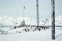
[19] The group expanded to Whalers Bay on Deception Island, where they hoisted the Chilean flag and established a coaling station.
Shackleton and his crew dragged three lifeboats over the frozen sea until they came to open water again, then sailed to the desolate Elephant Island at the very northern tip of the Antarctic peninsula.
Finally, in Punta Arenas, Shackleton obtained the help of the Chilean navy tugboat Yelcho, captained by Luis Pardo Villalón, which managed to rescue the remaining survivors.
Captain Pardo's feat, sailing with temperatures close to −30 °C (−22 °F) and a stormy sea of icebergs, won him national and international recognition.
1541 on September 7, he organized a commission which set the bounds of Chilean territory according to the theory of polar areas, taking into account geographical, historical, legal, and diplomatic precedents.
[citation needed] On May 4, 1955, the United Kingdom filed two lawsuits against Argentina and Chile before the International Court of Justice, to declare invalid the claims of sovereignty of the two countries in the Antarctic and sub-Antarctic areas.
In 1958, the U.S. president, Dwight Eisenhower, invited Chile to the International Geophysical Year Conference in an attempt to resolve the claiming issues.
[25] In February 2022, Chile submitted its second partial report regarding the Western Extended Continental Shelf of the Chilean Antarctic Territory.
[26][27] In August of the same year, it delivered oral presentations for both partial reports during the 55th Session of the United Nations Commission on the Limits of the Continental Shelf in New York.
Coastal areas north of the Antarctic Peninsula and in the South Shetland Islands, have a subarctic climate or tundra, that is, the average temperature in the warmest month exceeds 0 °C (32 °F) and much is permafrost.
The Antártica Commune had a population of 150 inhabitants on the Chilean bases according to a census conducted nationwide in 2012, corresponding to 54 civilians and 96 military.
This town, located next to the Presidente Eduardo Frei Montalva Antarctic base on King George Island, was opened on 9 April 1984 and has an airport, a bank, a school and child care, a hospital, a supermarket, mobile telephony and television.
As of 2024, Ignacio is the most recent Antarctic baby,[45][46][47][48][49] although the development of tourism has increased explosively through airplanes and cruise ships that depart from Punta Arenas or Ushuaia, with most of the flights arriving at King George Island handled by Dap Group.
There are four Chilean permanent bases operating throughout the year, while an additional five remain open only during the summer (December – March) with four seasonal shelters.
Belonging to Chile, this enclave forms the nucleus for important logistical support to other countries with scientific bases on King George Island.
The largest population center is located on King George Island and consists of Base Presidente Eduardo Frei Montalva which is connected to the communal capital, the village of Villa Las Estrellas, which has a town hall, hotel, day-care center, school, scientific equipment, hospital, post office and bank.
There is an airport, Teniente Rodolfo Marsh Martin Aerodrome, ICAO Code SCRM[53]) This enclave is a center of logistical support for the other eight countries with scientific bases on King George Island.


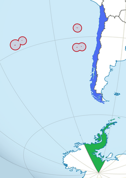
In blue: Continental Chile
In red: Insular Chile
In green: Antarctic Chile