Depth in a well
Strictly, depth is a vertical coordinate related to elevation, albeit in the opposite direction.
Common datums used are ground level (GL), drilling rig floor (DF), Rotary table (RT), kelly bushing (KB or RKB) and mean sea level (MSL).
Although it is an intuitive concept, depth in a well is the source of much confusion because it is frequently not specified correctly.
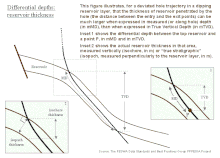
Example: the top of a reservoir may be found at 1,500 mMDRT in a particular well (1,500 m measured depth below the rotary table), which may be equal to 1,492 mTVDMSL (1,492 m true-vertical-depth below mean sea level) after correction for deviations from vertical.
Any combination of unit, path, and reference can be used, as long as they result in fully specified, unambiguous depths.