Spokane Valley, Washington
It is located east of Spokane, west of Coeur d'Alene, Idaho, and surrounds the city of Millwood on three sides.
The city formed from combining the urbanized unincorporated areas east of Spokane City, including census-designated places (CDPs) of Dishman, Opportunity, Trentwood, Veradale, part of Greenacres, and East Spokane.
The main arguments for incorporation centered around increased voice in local governance and the threat of annexation by the City of Spokane.
The main arguments against incorporation included contentment with Spokane County provided services and the threat of increased taxes and bureaucracy by the new city.
[13] To the south of the valley in which the city sits is the southern extent of the Selkirk Mountains, which are most prominent in the area east of Coeur d'Alene.
[15] The valley exhibits signs of the prehistoric geologic events that shaped the area and region such as the Missoula Floods which ended 12,000 to 15,000 years ago.
[16][17] The Spokane valley was gouged out by repeated failures in the ice dam that held Glacial Lake Missoula.
[13] The city is also part of the wider Inland Northwest region, consisting of eastern Washington, northern Idaho, northwestern Montana, and northeastern Oregon.
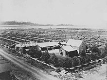
Prior to World War II, Spokane Valley had been a predominantly rural area, a productive site for farms and orchards since it was first irrigated in 1895.
[20] During World War II, with increased industrial activity in the central business district, particularly the railroads, new migrants to the Spokane area began to settle, shop, and do business in outlying areas where it was more quiet and less crowded and blighted.
Spokane Valley experiences a temperate climate (Köppen Csa), with a warm summer and rainy winter.
[21] Spokane Valley first appeared as a city in the 2010 U.S. Census after being incorporated in 2003 from all or the predominant parts of the deleted Dishman, Green Acres, Opportunity, Trentwood, and Veradale CDPs and additional area.
[31][32] The greater valley area is also home to the 59th temple of The Church of Jesus Christ of Latter-day Saints, dedicated in 1999,[33] which administers 15 regions across eastern Washington, northern Idaho, and northwestern Montana.
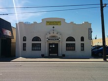
[38] The Spokane Valley Heritage Museum opened in 2005 and is located in the historic Spanish mission revivalist-style Opportunity Township Hall.
[42] The Spokane County Fair and Expo Center is home to dozens of various events throughout the year; it is situated on 97 acres (0.39 km2), with over 140,000 square feet (13,000 m2) of exhibition space, livestock facilities, indoor and outdoor arenas, lawns, and parking.
[44][45] Festivities include the Hearts of Gold parade down Sprague Avenue, "Fishing at the Falls", a classic car show, and a 5K or 10K run and duathlon that starts and ends at Plantes Ferry Park.
[47][48] The Indians play their home games at the 6,803-seat Avista Stadium and have won seven NWL titles since their Short-Season-A debut in 1982.
[58] The Mayor is appointed from among the councilmembers on a biennial basis at the first meeting of a new council and is the ceremonial leadership position in the city.
[69] The Spokane Valley Tech Skills Center and STEM Academy primarily serves high school students attending public and private high schools in the greater Spokane area and eastern Washington region.
[70] Historically, Spokane Valley had a four-year liberal arts college called Spokane University, which was founded in 1913 and was noted for its fine arts program which included Clyfford Still, a leading figure in the abstract expressionist movement as an alum; the university ceased operations in 1933 amidst the Great Depression.
Active higher education institutions in the Spokane Valley includes a campus of Carrington College, which primarily offers degree programs in healthcare fields such as medical assisting, veterinary assisting and medical billing and coding.
[20] The major retail corridor and one of the most highly trafficked arterial roads in the city is Sprague Avenue, which travels east–west from downtown Spokane to Liberty Lake.
[79] Sprague Avenue in Spokane Valley is designated as Interstate 90 Business and Trent Avenue carries the designation of Washington State Route 290, where it is routed from the Interstate 90 Hamilton interchange in Spokane northeast to the Idaho border.
[96] This is due to the rural beginnings of the neighborhoods that now make up the city of Spokane Valley and a legacy of the providers that came into operation to meet the needs of the agricultural consumers that predated the suburbanization of the area.
[96] The valley is serviced by Xfinity Comcast and Centurylink and some smaller telecom providers for cable TV and residential internet.