Springwood, New South Wales
Springwood is located 72 kilometres west of the Sydney CBD in the local government area of the City of Blue Mountains.
At the time of European settlement the chief of the clan was Oryang Jack who was drawn by French artist Pellier.
[5] In 1892, James Hunter Lawson built Braemar, a large, single-storey house situated on a sixty-acre property on Macquarie Road.
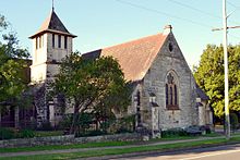
The Catholic community was originally part of the Penrith parish, but were given their own building in 1892: St Thomas Aquinas Church.
[12] Springwood's commercial area centres around Macquarie Road which runs parallel to the Great Western Highway and the railway line.
Unlike the upper Blue Mountains area, it generally has mild winters and warm summers, due in part to the foehn effect.
Although Springwood's elevation is at 371 m (1,217 ft), its winter nights are warmer than those of Penrith and Richmond in the lower Sydney metropolitan area, which lie on the footsteps of the Blue Mountains.
[22] Furthermore, Springwood can suffer bushfire damage during the spring and summer months due to it being located in, and surrounded by, a predominant Eucalyptus woodland area which encompass the Blue Mountains region.
The Blue Mountains Vietnam Veterans' Association conducts the largest annual parade and Memorial Service for Vietnam veterans in Australasia[26] at Springwood, on the third Sunday of August, to coincide with the anniversary of the Battle of Long Tan.
Fairy Dell is located immediately south of the township and has some tracks leading into the Blue Mountains World Heritage area.
The Deanei Reserve is another bushland area which is located east of the township and hosts the threatened and endangered Blue Mountains Shalecap Forest.
Buttenshaw Park is also a recreational area which hosts an arboretum, play structures and the Springwood Pool.
Its facilities include tennis and netball courts, a newly built skate park and fields for football (soccer).