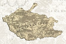
Stężyca Land
The land was composed of only one county, or powiat, and had its seat in the town of Stężyca after which it was named.
From the time of the fragmentation of Poland until the Late Middle Ages, the area of the later Stężyca Land belonged to Sieciechów Castellany within the Duchy of Sandomierz.
Due to the decline of Sieciechów as an urban centre caused by the changing course of the Vistula river, beginning in the 14th century its trade and administrative functions were gradually taken over by Stężyca.
It was an area mostly covered with primeval forest, with a small number of settlements concentrated along the valleys of Vistula, Wieprz, and Okrzejka rivers.
kilometres, with nine towns: Stężyca, Żelechów, Łaskarzew, Bobrowniki, Okrzeja, Adamów, Łysobyki, Wojcieszków and Maciejowice.