Saint Anthony Falls
Throughout the mid-to-late 1800s, various dams were built atop the east and west faces of the falls to support the milling industry that spurred the growth of the city of Minneapolis.
[3] The falls were renamed from their Dakota title in 1680 by Father Louis Hennepin after his patron saint, St. Anthony of Padua.
Dakota people camped on Nicollet Island upstream of the falls to fish and to tap the sugar maple trees.
According to the John Carter Brown Library, "Carver's purpose was to map the land, to befriend the native Americans, and to discover the Northwest passage.
As a result of his recommendations, the Army established Fort Snelling to guard against Indian incursions against settlers in the Upper Mississippi Valley.
Long recorded his experiences of the expedition in a journal, which was first published as Voyage in a Six-Oared Skiff to the Falls of St. Anthony, by the Minnesota Historical Society in 1860.
"[15][16] Following the establishment of Fort Snelling in 1820, the falls became an attraction for tourists, writers, and artists who sought inspiration, even if Hennepin's descriptions were not as majestic as hoped for.
[citation needed] By the 1850s a romantic "Indian legend" had become associated with the falls (first noted in Long's 1817 journal[16]), describing a wife whose husband had taken a second bride.
The offended first wife placed her child (or children) in a canoe and paddled toward the falls, plunging herself and her offspring to certain death as the husband looked on helplessly.
The first private land claim at the falls was made by Franklin Steele in 1838 — though he did not obtain financing for development until 1847, in the form of $12,000 for a nine-tenths stake in the property.
Godfrey knew the most efficient ways to use natural resources, like the falls, and the great pine forests, to make lumber products.
Steele created the St. Anthony Falls Water Power Company in 1856 with three New York financiers, Davis, Gebhard, and Sanford.
In 1868, the firm reorganized with new officers including John Pillsbury, Richard and Samuel Chute, Sumner Farnham, and Frederick Butterfield.
Shafts and tunnels from sawmills and other users weakened the limestone and its sandstone foundation, accelerating the falls' upriver erosion to 26 feet (7.9 m) per year between 1857 and 1868.
In the late 1860s, major milling innovations at the falls were a "middlings purifier" and "gradual-reduction" grinding, both borrowed from Europe.
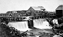
Mills built on both sides of the power canal diverted upper-level water into waterwheel-equipped vertical shafts (driven through the limestone bedrock into the soft, underlying sandstone) and then through horizontal tailrace tunnels to the falls' lower level.
But the Pillsbury A-Mill, built on the east bank and completed in 1881, was the world's largest flour mill for 18 years.
The early dams built to harness the waterpower exposed the limestone to freezing and thawing forces, narrowed the channel, and increased damage from floods.
A report in 1868 found that only 1,100 feet (340 m) of the limestone remained upstream, and if it were eroded away, the falls would turn into a rapids that would no longer be useful for waterpower.
Believing that the mills and all the other industries around the falls would be ruined, hundreds of people rushed to view the impending disaster.
The next year, an engineer from Lowell, Massachusetts, recommended completing a wooden apron, sealing the tunnel, and building low dams above the falls to avoid exposing the limestone to the weather.
[38] The fix for the tunnel disaster was a concrete dike constructed by the United States Army Corps of Engineers.
(The first large scale production of electricity in the world was at the Adams (Tesla) plant at Niagara Falls starting 1895).
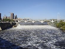
In 2015, the Upper St. Anthony Falls lock was permanently closed to stop the spread of invasive species, namely Asian carp.
The navigation channel required alteration of the historic Stone Arch Bridge, which now has a metal truss section to allow ships to pass below.
Geologists say that the falls first appeared roughly 12,000 years ago about 10 miles (16 km) downstream at the confluence of the glacial River Warren (at present-day Fort Snelling).
From its origins near Fort Snelling, St. Anthony Falls relocated upstream at a rate of about 4 feet (1.2 m) per year until it reached its present location in the early 19th century.
A Heritage Trail plaque nearby says, For untold generations of Indian people the Mississippi River was an important canoe route.
[65] The falls were a popular tourist attraction at the time, and were depicted in many paintings, including works by Albert Bierstadt, Henry Lewis, and George Catlin.
Twain noted that the waterfall's industrial capacity was "of inestimable value, business-wise, though somewhat to the damage of the Falls as a spectacle, or as a background against which to get your photograph taken".