St. Francois Mountains
[5] Others propose that Jacques Marquette, a French Jesuit, named the river when he explored its mouth in present-day Arkansas in 1673.
The subvolcanic granites are the most widespread igneous rocks and were thought to have been covered with extensive volcanics that have been removed by erosion.
[7] The Saint Francois Mountains were formed by igneous activity, whereas most of the surrounding Ozarks are developed on Paleozoic sedimentary rocks as a dissected plateau.
The localized vertical relief was caused by erosion following uplift during the Pennsylvanian and Permian periods produced by the Ouachita orogeny to the south.
Elevations and strata dips in the Ozark structural dome generally radiate downward and outward away from the Saint Francois mountains.
These ancient mountains may be the only area in the Midwestern United States never to have been submerged, (as evidenced by the lack of marine fossils) existing as an island archipelago in the Paleozoic seas.
These ancient reef complexes formed the localizing structures for the mineralizing fluids that resulted in the rich ore deposits of the area.
Hughes Mountain contains a good example of columnar jointing in igneous rhyolite, the same process that formed Devils Tower in Wyoming and the Giant's Causeway in Ireland.
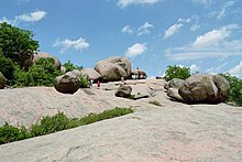
Five Missouri state parks – Johnson's Shut-Ins, Taum Sauk Mountain, St. Joe, Sam A. Baker and Elephant Rocks – are located in this region.
Public lands held by the Missouri Department of Conservation provide access for hiking, backpacking, hunting, fishing, canoeing, and boating.
The Mark Twain National Forest contains additional public lands, including the Bell Mountain Wilderness.