St. Joseph Island (Ontario)
[4] Its location on the Great Lakes, ease of reach by road and boat and the availability of local services have made it a destination for tourists and cottagers in northeastern Ontario.
St. Joseph Island played an important role for First Nations and Europeans in the early fur trade and as a staging point for the first victory for British North America in the War of 1812.
The island is the subject of one of the Upper Canada Land Surrender treaties conducted by the British government and First Nations in the period between the end of the American Revolution and Confederation.
The Shield people, likely descendants of the Plano, came south from the Tyrrell Sea (a much larger Hudson Bay) and travelled along the northern shores of lakes that are today Superior and Huron.
[6] By the time the Europeans began arriving in the 1630s, the north channel of Lake Huron was shared by the Ojibwe, Odawa and Potawatomi whose Algonkian ancestors had come from the east around 1200.
St. Joseph Island became a strategic mid-way point for French explorers, missionaries and fur traders on the long voyage between Quebec and Lake Superior.
Included in the French assets was the strategically important fort at the Straits of Mackinac between lakes Huron and Michigan 50 km (31 mi) west of St. Joseph Island.
For instance, an influential map produced by American engraver Abel Buell based on the treaty instructions appears to divide St. Joseph in half.
He felt the strongest defensive position in the event of an American attack would be to concentrate the relatively thin British forces closer to the strategic centres of Quebec and Montreal.
[19] On April 11, 1796, Dorchester ordered a garrison of 14 men to set up a camp on the southwest corner of the island close to the channel between Mackinac and Sault Ste.
[20] This advance detachment, led by Lieutenant Andrew Foster of the Queen's Rangers identified a spot of high ground nearby to suitable for a fort.
[18] On June 16, 1798, the deputy superintendent of Indian affairs, Alexander McKee departed Amherstburg on the Detroit River on the ship Francis to negotiate with Ojibwe chiefs for the purchase of St. Joseph Island, held under lease to that point.
11" is one of the Upper Canada Land Surrender treaties conducted by the British government and First Nations in the period between the end of the American Revolution and Confederation.
In time, Fort St. Joseph became an important point for trade and commerce in the region, receiving vessels and their goods from Detroit, Mackinac and Sault Ste.
John Askin Jr., the appointed storekeeper described the situation to his brother in January 1808: "To give you some idea of this place, first its an Island abounding with Rocks, and not a Deer, Bear, Racoon, Moose, Cariboux or Muskrat about it.
However, in order to resolve territorial claims that had precipitated the war, negotiators at Ghent established a process whereby commissioners would survey the boundary to determine the borders envisioned in the original treaty.
The agent for the American survey team, Major Joseph Delafield complained "No map that I have seen has any truth as it respects the position of Drummond's or the other islands about St. Marys.
"[13] Relying on the surveys taken in the summers of 1820 and 1821, the commissioners, Anthony Barclay of the United Kingdom and the American General Peter B. Porter met in New York City for four weeks in November and December 1821.
Exploring a creek in the southeast corner of the island, one of the commission survey teams reported "a neat log house far up in the woods, with a patch of Indian corn, and other vegetables.
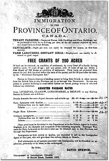
[39] A government report on the progress of the settlement in July 1839 found only ten small homes at the Milford Haven, several of which were occupied by French Canadians and Metis fishermen who had been living on the island prior to the start of Rains' colony.
In 1912, the Stone Lumber Company at Marksville had added 13 km of railroad with a locomotive to reach dense woodlots up the mountain and deliver timber to the mill.
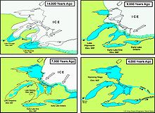
As the Laurentide Ice Sheet, a huge glacier extending into the present-northern United States, melted about 11,000 years ago, it carved deep gouges into the earth, scraped off top soil and deposited rock and sand.
[60] On most of the island, surface soil consists of boulders, pebbles, sand, silt, and clay believed to have been deposited by retreating glacial ice.
[56] A creation of Precambrian rivers and later metamorphism, "St. Joseph Island puddingstone" is distinctive for its bright red and brown jasper pebbles suspended in white quartzite.
[64] St. Joseph Island forms the northwesternmost point of the Mixedwood Plains ecozone that stretches through southern Ontario to the St. Lawrence shore to Quebec City.
A description from the summer of 1866, before large scale commercial logging and general settlement began, provides an inventory of the impressive variety of tree cover of the time: "On the dry gravelly soil of St. Joseph Island a very heavy growth of hard-wood forest was found, consisting of beech, hard maple, hemlock, basswood, black and yellow birch, with a few rather scraggy white pines; while on the lower ground they were almost replaced with black ash, cedar, balm-of-Gilead and aspen-poplar, balsam-fir, elm, mountain-ash, and many small and arborescent shrubs.
The sanctuary, established in 1951 to protect migratory birds from extensive hunting, includes a large marsh along the St. Marys River shoreline, a few small lakes and swamps as well as several islands.
Two events organized in the spring and fall by the local arts community invite people to visit the home studios and shops of artists around the island.
[84] The island's maple syrup festival is held each spring, including a traditional all-you-can-eat pancake and sausage meal prepared by the local branch of the Royal Canadian Legion.
The St. Joseph Island Airport is a private airstrip located about halfway between Richards Landing and Hilton Beach consisting of a 732 m (2,402 ft) turf runway.