St. Lawrence, Toronto
The Esplanade off Yonge St., lined with restaurants, cafés and hotels runs through the middle of the area.
Much of the area of today's St. Lawrence neighbourhood was then located in Toronto Harbour, the shoreline being just south of Front Street.
A larger city hall, also housing a police station and jail cells, opened in 1845 with a 140 feet (43 m) long facade running along the south side of Front Street.
[2] Ostensibly for carriages and carts, the roadway eventually became primarily the route for rail lines in the central core.
[3] Commercial activity along Toronto's bustling harbour provided employment and was the primary place of entry to the quickly growing, burgeoning city.
The convergence of the railway lines and the wharves must have worked because in 1873 historian Henry Scadding so eloquently wrote in his book Old Toronto of The Esplanade "...It has done for Toronto what the Thames Embankment has done for London..." In the 1920s, the railway lines were relocated to a new, raised viaduct to the south of the Esplanade.
In the 1970s it was decided by Toronto Mayor David Crombie to turn the area into a new residential neighbourhood, but one that would not make the same mistakes of the "urban renewal" housing projects of earlier decades.
The neighbourhood was planned by Alan Littlewood and Frank Lewinberg, with the influence of American-Canadian urban planner Jane Jacobs playing a crucial role.
Since that time, the St. Lawrence neighbourhood has been critically acclaimed as a major success in urban planning.
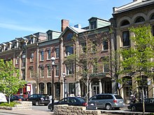
Some of the most interesting architecture in the city can be found in St. Lawrence, one notable landmark is the Flatiron building, known for its distinct narrow, wedge shape where Wellington St. merges with Front.
If viewed from the east, the wedge can be seen in the foreground with the financial skyscrapers and the CN tower rising in the background.