California State Route 178
The gap in between segments is connected by various local roads and State Route 190 through Death Valley National Park.
The western segment runs from State Route 99 in Bakersfield and over the Walker Pass in the Sierra Nevada to the turnoff for the Trona Pinnacles National Natural Landmark.
If the unconstructed portion were built, it would also provide an easy route between Ridgecrest, California and Las Vegas, via Pahrump, Nevada.
Turning northeast, the road narrows to a 4-lane highway and continues to the mouth of Kern Canyon (which is also the northeastern city limits of Bakersfield).
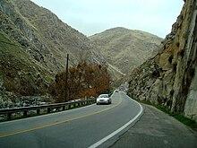
For the next approximately 8 miles, the route is a narrow 2-lane road (average width of 18 ft. to 24 ft.), as it ascends the lower Sierra Nevada.
The constructed highway then ends east of Ridgecrest at the turnoff for the Trona Pinnacles National Natural Landmark in Searles Valley.
[7] In 1933, the final segment was added to LRN 58, which created a route from US 101 near Santa Margarita to the Nevada state line via Bakersfield.
The first phase of construction was completed in 1974, which created a short freeway near Lake Isabella and a 60’ wide expressway extending west to China Garden.
[12] The freeway portion of Route 178, completed in the late 1950s, ends as it approaches downtown Bakersfield from the east.
Weak public support and subsequent lack of funds hindered efforts to complete the freeway through downtown and Westchester to its proposed terminus at the beginning of the modern-day Westside Parkway.
Although freeway alternatives through various neighborhoods have been studied several times following the existing portion's completion in 1968, the city of Bakersfield never formally endorsed a route.
Caltrans formally announced preference for an alignment through downtown and Westchester in 1973, but fierce public opposition coupled with the historic integrity of the neighborhoods slated to be demolished greatly hindered momentum of the project.
As it continued through Westchester the freeway would turn southwest, cross under SR 99 and terminate at the newly completed Westside Parkway.
[13] A southern alignment would start at SR 178 at Baker Street, about 0.7 miles east of its current terminus.
From there, it would turn southwest and run parallel to Baker Street, through East Bakersfield, to the BNSF railroad yard.
It would then turn west and run south of the railroad tracks through the southern end of Downtown Bakersfield.
The state is considering three options: select an alignment to connect with the current eastern segment at its present location; select an alignment to avoid traversing the Death Valley Wilderness; or delete this unconstructed segment from the State Highway System.
[18] Except where prefixed with a letter, postmiles were measured on the road as it was in 1964, based on the alignment that existed at the time, and do not necessarily reflect current mileage.