U.S. Route 395 in California
U.S. Route 395 (US 395) is a United States Numbered Highway, stretching from Hesperia, California to the Canadian border in Laurier, Washington.
The California portion of US 395 is a 557-mile (896 km) route which traverses from Interstate 15 (I-15) in Hesperia, north to the Oregon state line in Modoc County near Goose Lake.
The corridor has been used since the California gold rush, and before numbering was known by several names including El Camino Sierra.
[6] US 395 is eligible to be included in the State Scenic Highway System,[7] and is officially designated as a scenic highway by the California Department of Transportation from Fort Independence to Fort Springs Road in Inyo County, and from the Inyo–Mono county line to south of Walker.
After leaving the Victorville area, the scenery changes as suburban neighborhoods disappear and the highway traverses the Mojave Desert.
While crossing the desert, the route clips the northeastern corner of Edwards Air Force Base.
US 395 passes between the cities of Ridgecrest and Inyokern, where US 395 Business is routed on South China Lake Boulevard.
[16] US 395 follows the western boundary of the Naval Air Weapons Station China Lake, not far from Big and Little Petroglyph Canyons, where the Coso People created prolific rock art and traded with distant tribes using tools crafted of stone.
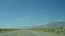
US 395 follows the valleys along the eastern edge of the Sierra Nevada as the mountains gradually increase in altitude until reaching their peak at over 14,000 feet (4,300 m) near Lone Pine.
The valley, named for one of explorer John C. Fremont's guides, was primarily home to the Timbisha and Paiute peoples before European settlement.
[19] Past Lone Pine, the highway passes by Manzanar National Historic Site, a concentration camp where Japanese Americans were imprisoned during World War II.
Nearby is where the Los Angeles Aqueduct is tapped from the Owens River; with more vegetation visible north of this point.
At the north end of Bishop is the former separation with, and current terminus of, US 6, a 3,205-mile (5,158 km) route which travels eastward across the US to Provincetown, Massachusetts on the east coast.
[15] The scenery changes dramatically past Bishop as the highway reaches the end of the valley and with a single ascent, gains over 3,000 feet (910 m) in elevation.
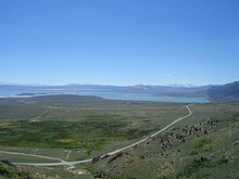
Just before arriving at Mono Lake, US 395 has a brief concurrency with SR 120; the two routes separate at the southern end of Lee Vining.
At this junction US 395 is 12 miles (19 km) from Tioga Pass, along SR 120, the highest paved through route in California, and the eastern boundary of Yosemite National Park.
Along the descent the highway passes by a turnoff to Bodie, a ghost town which the state park system has preserved, including items still on the shelves in the abandoned stores.
[23] The fourth summit crossed by US 395 in California is Devil's Gate Pass, elevation 7,519 feet (2,292 m), which separates the East and West Walker Rivers.
The highway runs for 87 miles (140 km) in Nevada, with a significant portion built to freeway standards and co-designated Interstate 580.
A short segment in Lassen County is a freeway with one exit serving SR 70 at the Hallelujah Junction.
[25] Though SR 70 does not directly serve any major cities, the highway is noted as an all-weather crossing of the Sierras.
[26] SR 70 was at one time numbered U.S. Route 40 Alternate, using US 395 from this junction south to Reno to connect with the mainline US 40 (now I-80).
Past the confluence, the highway follows North Fork Pit River across Modoc County toward Goose Lake.
The trail was in common use by prospectors passing through the area because of the California gold rush and Comstock Lode.
After these mining rushes died down, the Camino Sierra saw a revival because of the construction of the Los Angeles Aqueduct beginning in 1908.
The route was promoted for its scenic value by the Southern Pacific Railroad, as a side trip from its rail lines, as far back as 1912.
[31] By 1918, the Camino Sierra had been included in the Automobile Blue Book, an early road atlas of the United States.
In 2022, construction began on a bypass of Olancha and Cartago,[43] which has been controversial as most residents preferred improving the existing route.
[48][49] With the fast growth of the Victorville area, Caltrans and the county governments have noted a dramatic increase in congestion and accidents along the route.
[53] Except where prefixed with a letter, postmiles were measured on the road as it was in 1964, based on the alignment that existed at the time, and do not necessarily reflect current mileage.