Washington State Route 21
Between Lincoln and Ferry counties, the roadway crosses Franklin D. Roosevelt Lake on the Keller Ferry, operated fare free by the Washington State Department of Transportation (WSDOT) and the Department of Highways (DoH) since 1930.
After leaving Kahlotus as the Lind–Kahlotus Road, the highway turns northeast and later west as it passes over the Sand Hills Coulee four times.
[3] From the interchange, the highway travels west and intersects Smart Road again before crossing over the Centennial Trail and entering Downtown Lind.
[5][6][7] In Lincoln County, the highway travels through farmland to encounter Odessa as Division Street, intersecting SR 28.
After temporarily turning east into more farmland, the road enters Wilbur, named Bruce Avenue.
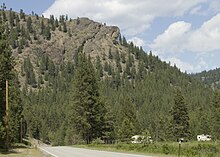
North of Wilbur, the roadway enters the top of Speigle Canyon and makes a winding descent before exiting at the floor of the canyon and nearing Franklin D. Roosevelt Lake; at 80,000 acres (323.75 km2), the lake is the largest in Washington.
Between Republic and the Canada–US border, an estimated daily average of 1,600 motorists used this segment of SR 21, making this section the busiest.
[16][17] After passing through more dense forests, the roadway enters Danville, where SR 21 crosses the Canada–US border into British Columbia as Highway 41 (BC 41).
[18] SR 21 originated as the Marble Mount Road that extended from the north end of the Keller Ferry to Republic and was established in 1899.
[27] The speed limit between Curlew Lake State Park and the community of the same name was temporarily lowered on March 9, 2009 to 35 miles per hour (56 km/h) due to cracks in the pavement.
The ferry originated as an oar-propelled canoe that was used by Native Americans prior to the late 19th century.
In the early 1890s a four-car cable ferry, owned and operated by Todd Clark and William Robertson, was established.
[35][36] The Keller Ferry was repaired on February 15, 2007 to expand its lifespan; WSDOT detoured traffic onto SR 174.
[42] Due to the prohibitive cost of having to specially manufacture many replacement parts, the Martha S was retired on July 7, 2013.