California State Route 78
The route is a freeway through the heavily populated cities of northern San Diego County and a two-lane highway running through the Cuyamaca Mountains to Julian.
In Imperial County, SR 78 travels through the desert near the Salton Sea and passes through the city of Brawley and the Algodones Dunes before turning north on the way to its terminus in Blythe.
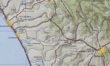
After leaving the San Pasqual Valley, the road follows a serpentine alignment, heading south to enter the community of Ramona as Pine Street.
The highway leaves Ramona as Julian Road, which continues on a winding mountain alignment through Witch Creek to Santa Ysabel where it meets SR 79.
[13][14] An informal nickname for the road is "the Hops Highway," referring to the fact that the 60-mile (97 km) stretch of SR 78 from Oceanside to Julian passes by one-third of all the breweries in San Diego County.
The section of SR 78 from the western junction of SR 79 to the western junction with SR 86 is designated by the California State Legislature as eligible by law for the State Scenic Highway System;[17] however, only the section in Anza-Borrego Desert State Park has officially been designated by Caltrans as being part of the system,[18] meaning that it is a substantial section of highway passing through a "memorable landscape" with no "visual intrusions", where the potential designation has gained popular favor with the community;[19] it gained this status in 1971.
[28] Before the designation of SR 78, a road known as the Brawley-Westmorland-Julian-Oceanside Highway (connecting Oceanside, Escondido, Ramona, Julian, Westmorland, and Brawley) existed during the early twentieth century.
East of the Sand Hills, there was a road from Glamis passing by Smith Well into Palo Verde, which roughly follows the routing of SR 78.
[38] Those living in Calipatria and Westmorland supported the prospect of the road to Julian being improved, and included in the state highway system.
[41] In June 1930, an agreement was made between the county and the state to share in the construction and maintenance on the road to Kane Springs from Julian; prison crews were to make up some of the workforce.
[22][48] By 1947, US 395 ran concurrently along the portion of SR 78 from Vista to Escondido before continuing along Santa Fe Avenue to Bonsall and Fallbrook and rejoining its alignment during the 1970s.
[54] The center portion of the Vista Way Freeway opened in April 1962,[55] but the western part of the route was not entirely access controlled, as an expressway.
[59] The rest of the freeway between Nordahl Road and US 395 opened on December 21, 1964, providing a four-lane highway from Escondido to Oceanside; the segment cost $1,865,000[60] (about $14.2 million in 2023 dollars).
[64] The interchange, previously an at-grade intersection, improved traffic flow to the college by removing the left turn across the highway needed to access it.
However, at the end of the month, the United States Navy obtained ownership from Imperial County of the old Niland–Blythe road running through the Chocolate Mountain Aerial Gunnery Range for the specified amount.
[84] According to an Imperial County official, the road was predicted to be more busy than US 80 and to bring traffic to San Diego directly from Needles and US 66.
[90] In 1969, plans to extend the freeway portion of SR 78 east from the Broadway interchange through Escondido were delayed by Caltrans director Jacob Dekema due to a lack of funding until 1980.
[92] The majority of the Escondido City Council supported sending representatives to the upcoming California Coastal Commission meeting in January 1971 to expedite the process of construction.
[94] In April 1972, the majority of voters supported a referendum that halted plans to build the SR 78 freeway through the city of Escondido.
[97] City officials expressed a desire to have SR 78 included in the Interstate Highway System in 1985, but this was determined unlikely to succeed by state senator William Craven.
[99] The San Diego County Board of Supervisors endorsed the project that month, in order to have the best chance at getting federal funding.
Congress passed the bill in April 1987, overriding Reagan's veto, in the same legislation that allowed for rural Interstates to have a speed limit of up to 65 miles per hour (105 km/h).
[46] Caltrans predicted that without the widening project, traffic speeds on SR 78 would be as low as 15 miles per hour (24 km/h) by the year 2000 because of congestion.
[46] The San Marcos Boulevard interchange was renovated beginning in late 1996, but encountered difficulties in the land acquisition process.
[115] Work resumed in 1999, and was expected to be finished by 2000, at a cost of $10 million; the benefits of decreased congestion came into effect once the new westbound offramp was opened.
[128] On the third phase of the project, from the junction with SR 86 west of Brawley to the western end of the completed bypass, construction began in late 2010.
[132] There are also plans to improve the interchange with I-5, which currently involves a traffic signal connecting Vista Way and SR 78 with the ramps to I-5 southbound.
[136] A 2011 Caltrans report proposed adding two high-occupancy vehicle lanes to the freeway portion of SR 78 between I-5 and I-15 to accommodate increased traffic.
[6] In early 2016, the mayor of San Marcos stated that there were plans to add another lane in each direction to SR 78 through parts of the city.
[137] Except where prefixed with a letter, postmiles were measured on the road as it was in 1964, based on the alignment that existed at the time, and do not necessarily reflect current mileage.