Stone Bridge (Regensburg)
Since modern barge traffic requires more clearance than the arches of the bridge provide, this stretch of the river is now only used by recreational and excursion shipping.
Larger watercraft bypass it to the north by means of the Regensburg Regen-Danube Canal, which was built on the flood plain called the Protzenweiher which had been used for a cattle market and public amusements[7][8][9] and forms part of the European Water Route between Rotterdam at the mouth of the Rhine and Constance on the Black Sea.
For centuries it was the only bridge over the river between Ulm and Vienna, making Regensburg a major centre of trade and government.
[13] The bridge originally had its own administration, using a seal depicting it, the oldest example of which dates to 1307; tolls were used for its upkeep.
At the south end, the first arch and first pier were incorporated into the Regensburg Salt Store when it was built in 1616–20, but remain in place under the approach road to the bridge.
[5][15] Construction of the bridge was made easier by an unusually hot, dry summer in 1135, which caused very low water levels in the Danube.
[15] The construction using abutments is a modification of the technique used by the Romans for the bridge over the Mosel at Trier, where the piers rest directly on the riverbed.
The Bavarians had them burnt in 1633 during the Thirty Years' War; some were rebuilt in 1655 but in 1784 an ice dam on the river destroyed them.
[17] In the Thirty Years' War, during the Swedish attack on the city in 1633, the fourth bridge span (the third now visible) was blown up.
The gap was filled by a wooden drawbridge and only repaired in 1790/91 after it became apparent that the missing section was weakening the bridge.
[20] Both the south and the middle towers were destroyed by fire in the Thirty Years' War, when the city was under occupation by the Swedes.
[21] This tower was damaged in 1809 during the Napoleonic Wars when the French and Bavarians retook the city from the Austrians, and had to be demolished the next year.
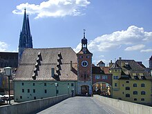
The north end of the bridge was formerly the border between the Duchy (later Electorate) of Bavaria and the Free Imperial City of Regensburg.
[22] The bridge also has a number of other sculptures: full statues of Emperor Friedrich II (standing on a masked head with ram's horns, and originally on the now demolished north tower; the current statue is a 1930 replica),[25] Philip of Swabia and his consort Queen Irene (both enthroned and originally on the middle tower; Philip's sculpture is a replica)[26][27] and reliefs including various arms (including both the city and the bridge itself),[14] heads that may be those of the original builder and the rebuilders later in the Middle Ages,[28] a lizard,[29] a basilisk,[30] a weasel,[31] a lion (replaced with a replica in 1966),[32] two roosters fighting[33] and a reclining dog.
[20] The roosters and the dog have been related to the legend about the building of the bridge;[23] alternatively the Bruckmandl, the basilisk, the dog, the three heads and a now lost "small stone within a large stone" which was in the floor of the watchman's hut next to the middle tower[20] have all been interpreted as Christian symbolism indicating that the bridge was the work of a school of clerical architects.
[37] For over a decade, the bridge was closed to private vehicles, and beginning in 2005 it was remotely monitored 24 hours a day from Nuremberg for signs of impending collapse.
[39] The State of Bavaria conducted a thorough search taking two years and costing 100,000 € to find appropriate stone to use in restoration, similar in colour and structure to the original material of the bridge and sufficiently tough and resistant to weathering.