Stony Brook (Charles River tributary, Boston)
It powered industries and its clear waters attracted breweries, but the surrounding lands tended to flood during heavy rains and freshets.
It flows about 1 mile (1.6 km) southeast through the park, then enters a conduit near the intersection of Enneking Parkway and Gordon Avenue.
[2][1] The conduit zig-zags under residential areas, then follows the Northeast Corridor railroad line north for about 0.8 miles (1.3 km).
It wanders north through residential areas of Hyde Park, Roslindale, and Jamaica Plain, largely paralleling the railroad line.
[3][2] A pair of stone gatehouses (one disused) are located on the north side of the Fenway in the Back Bay Fens.
The Stony Brook discharges into the Charles River Basin north of the gatehouse, just upstream of the Harvard Bridge.
[2][1] The two branches of Goldsmith Brook run between Jamaica Pond and Arnold Arboretum, combining near the Arborway and meeting the main conduit near Boylston Street.
[2] It is partially fed from Scarborough Pond in Franklin Park and has a surface segment along American Legion Highway.
[3] After the 1873 annexation of Hyde Park, a similar channel was extended south from Roxbury Crossing to Jamaica Plain in 1880–84.
[3] Heavy rain and melting snow in February 1886 resulted in flows of 500 cu ft/s (14 m3/s), overwhelming the capacity of the culvert north of Roxbury Crossing.
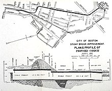
[3][4] In 1887–89, a bypass conduit (the Commissioner's Channel) was constructed from Roxbury Crossing to Huntington Avenue, largely under Parker Street.
[12] The railroad was raised onto an embankment through the Stony Brook Valley in the 1890s to eliminate grade crossings, and Columbus Avenue was widened around the same time.
[13][14] In 1896, the Boston Globe asserted that the "apparently inconsequential waterway has in its history cost more money to control and provide for than probably anything of its size in this part of the country".
[21] During the 1912–1914 construction of the Boylston Street subway, the Muddy River was temporarily redirected through the Stony Brook conduit.
[31][32][33] The remaining surface sections in Roslindale and Hyde Park (outside the Stony Brook Reservation) were placed in conduits in the 1930s to 1950s.
[37] Three years later, a former Stony Brook culvert under the railroad (disused decades before when the river was placed underground) at the end of the street was reused as a pedestrian underpass.