Storm Prediction Center
SELS began issuing convective outlooks for predicted thunderstorm activity in 1955, and began issuing radar summaries in three-hour intervals in 1960;[3] with the increased duties of compiling and disseminating radar summaries, this unit became the National Severe Storms Forecast Center (NSSFC) in 1966,[4] remaining headquartered in Kansas City.
In 1968, the National Severe Storms Forecast Center began issuing status reports on weather watches; the agency then made its first computerized data transmission in 1971.
At that time, the guidance center was housed at Max Westheimer Airport (now the University of Oklahoma Westheimer Airport), co-located in the same building as the National Severe Storms Laboratory and the local National Weather Service Weather Forecast Office (the latter of which, in addition to disseminating forecasts, oversees the issuance of weather warnings and advisories for the western two-thirds of Oklahoma and western portions of North Texas, and issues outline and status updates for SPC-issued severe thunderstorm and tornado watches that include areas served by the Norman office).
[1] In 1998, the center began issuing the National Fire Weather Outlook to provide forecasts for areas potentially susceptible to the development and spread of wildfires based on certain meteorological factors.
[3][5] Since the agency's relocation to Norman, the 557th Weather Wing at Offutt Air Force Base would assume control of issuing the Storm Prediction Center's severe weather products in the event that the SPC is no longer able to issue them in the event of an outage (such as a computer system failure or building-wide power disruption) or emergency (such as an approaching strong tornadic circulation or tornado on the ground) affecting the Norman campus; on April 1, 2009, the SPC reassigned responsibilities for issuing the center's products in such situations to the 15th Operational Weather Squadron based out of Scott Air Force Base.
This involves conducting applied research and writing technical papers, developing training materials, giving seminars and other presentations locally and nationwide, attending scientific conferences, and participating in weather experiments.
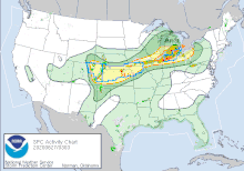
[20] The categorical levels of risks are TSTM (for Thunder Storm: light green shaded area – rendered as a brown line prior to April 2011 – indicating a risk for general thunderstorms), "MRGL" (for Marginal: darker green shaded area, indicating a very low but present risk of severe weather); "SLGT" (for Slight: yellow shaded area – previously rendered as a green line – indicating a slight risk of severe weather); "ENH" (for Enhanced: orange shaded area, which replaced the upper end of the SLGT category on October 22, 2014); "MDT" (for Moderate: red shaded area – previously rendered as a red line – indicating a moderate risk of severe weather); and "HIGH" (pink shaded area – previously a rendered as a fuchsia line – indicating a high risk of severe weather).
Significant severe areas (referred to as "hatched areas" because of their representation on outlook maps) refer to a threat of increased storm intensity that is of "significant severe" levels (F2/EF2 or stronger tornado, 2 inches (5.1 cm) or larger hail, or 75 miles per hour (121 km/h) winds or greater).
[21] In April 2011, the SPC introduced a new graphical format for its categorical and probability outlooks, which included the shading of risk areas (with the colors corresponding to each category, as mentioned above, being changed as well) and population, county/parish/borough and interstate overlays.
[21] A slight risk day typically will indicate that the threat exists for scattered severe weather, including scattered wind damage (produced by straight-line sustained winds and/or gusts of 60 to 70 mph), scattered severe hail (varying in size from 0.25 inches (0.64 cm) to 1.75 inches (4.4 cm)) and/or isolated tornadoes (often of shorter duration and varying weak to moderate intensity, depending on the available wind shear and other sufficient atmospheric parameters).
Numerous tornadoes (some of which may be strong and potentially long-track), more widespread or severe wind damage (often with gusts over 80 miles per hour (130 km/h)) and/or very large/destructive hail (up to or exceeding 3 inches (7.6 cm) in diameter) could occur.
This includes a large number of tornadoes - many of which will likely be strong to violent and on the ground for a half-hour or longer, or widespread and very destructive straight-line winds, likely in excess of 100 miles per hour (160 km/h).
[20] The Storm Prediction Center began asking for public comment on proposed categorical additions to the Day 1-3 Convective Outlooks on April 21, 2014, for a two-month period.
[24] The Storm Prediction Center broadened this system beginning on October 22, 2014 by adding two new risk categories to the three used originally.
[29] The categories at right refer to the risk levels for the specific severe weather event occurring within 25 miles (40 km) of any point in the delineated region, as described in the previous section.
[20] Probabilities for tornadoes, hail and wind applying to the Day 1 Convective Outlook were incorporated into the Day 2 Convective Outlook on January 28, 2020, citing research to SPC operations and improvements in numerical forecast guidance that have increased forecaster confidence in risk estimation for those hazards in that timeframe.
Areas are delineated in this forecast that have least a 15% or 30% chance of severe weather in the Day 4–8 period (equivalent to a slight risk and an enhanced risk, respectively); as forecaster confidence is not fully resolute on how severe weather will evolve more than three days out, the Day 4–8 outlook only outlines the areas in which severe thunderstorms are forecast to occur during the period at the 15% and 30% likelihood, and does not utilize other categorical risk areas or outline where general (non-severe) thunderstorm activity will occur.
Generally, the convective outlook boundaries or lines – general thunderstorms (light green), marginal (dark green), slight (yellow), enhanced (orange), moderate (red) and high (purple) – will be continued as an arrow or line not filled with color if the risk area enters another country (Canada or Mexico) or across waters beyond the United States coastline.
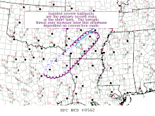
[34] MCDs contain meteorological information on what is happening and what is expected to occur in the next few hours, and forecast reasoning in regard to weather watches.
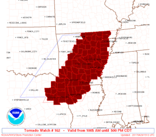
Watches (WWs) issued by the SPC are generally less than 20,000–50,000 square miles (52,000–129,000 km2) in area and are normally preceded by a mesoscale discussion.
[37] They indicate that conditions are favorable for thunderstorms capable of producing various modes of severe weather, including large hail, damaging straight-line winds and/or tornadoes.
[38] A PDS severe thunderstorm watch is very rare and is typically reserved for derecho events impacting densely populated areas.
[37] The process of issuing a convective watch begins with a conference call from SPC to local NWS offices.
[37] The Storm Prediction Center also is responsible for issuing fire weather outlooks (FWD) for the continental United States.
Critical Fire Weather Areas for Wind and Relative Humidity are typically issued when strong winds ( > 20 mph (32 km/h); 15 mph (24 km/h) for Florida) and low relative humidity (usually < 20%) are expected to occur where dried fuels exist, similar to a slight, enhanced, or moderate risk of severe weather.