Weather Prediction Center
They also forecast precipitation amounts for the lower 48 United States for systems expected to impact the country over the next seven days.
Long range climatological forecasts are produced by the Climate Prediction Center (CPC), a branch of the National Weather Service.
From the early days of organized weather collection in the United States, a central facility was used to gather and disseminate data.
a single room within the United States Army Signal Service in Washington, D.C. Reports were collected via telegraph and general forecasts were made for the country.
the organization can be most directly traced to the formation of the Analysis Center by Circular Letter 39-42, signed by Weather Bureau Director Francis W. Reichelderfer on March 5, 1942.
[6] Research and computer processing abilities increased over the years, which allowed for the first global forecast model to run by June 1966.
By January 1975, much of the facility, minus the computers, moved to the World Weather Building, located in nearby Camp Springs, Maryland.
[5] During August 2012, HPC moved to a new building, the National Center for Weather and Climate Prediction (NCWCP), in College Park, Maryland.
The Winter Weather Desk issues probabilistic heavy snow and icing guidance products for the next three days.
The forecasts represent the probability that freezing rain or combined snow/sleet accumulations will meet specific criteria within a 24-hour period.
These products are issued twice daily using guidance from the NWS's Global Forecast System (GFS) and North American Mesoscale Model (NAM), as well as guidance from the European Centre for Medium-Range Weather Forecasts (ECMWF), the United Kingdom's Met Office (UKMET), the Meteorological Service of Canada, including ensembles.
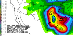
The medium range forecast products include surface pressure patterns, circulation centers and fronts, daily maximum and minimum temperatures and anomalies, probability of precipitation in 12-hour increments, total 5-day precipitation accumulation for the next five days, and 500 hPa (mb) height forecasts for days 3–7.
Through 2008, WPC provided track forecast guidance to the NHC whenever there is a tropical cyclone in the Atlantic Ocean basin west of 60W longitude.
The WPC participates in the Hurricane Hotline call with the NHC and other forecast offices and government agencies at 1700 UTC for tropical cyclones in the Atlantic Ocean basin west of 60W longitude.
This coordination call began between the Extended Forecast Section and the Miami Hurricane Warning Office prior to 1959.
This statement is included in the Public Advisory issued by the NHC, and is a forecast of expected rainfall amounts that will occur with the tropical cyclone.
[13] Mesoscale discussions (MDs) once were issued by the Storm Prediction Center (SPC) for both convective (MCDs) and precipitation (MPDs) events but WPC now covers this heavy rainfall function.
The International desks have a variety of responsibilities, primarily the training of foreign visitors in the use of Numerical Weather Prediction products.