Strohn
The municipality lies in the Vulkaneifel, a part of the Eifel known for its volcanic history, geographical and geological features, and even ongoing activity today, including gases that sometimes well up from the earth.
Strohn lies south of Gillenfeld and the Pulvermaar, a local volcanic crater lake, on the river Alf’s left bank.
The following hamlets and homesteads belong to Strohn: Altheck, Buchholz, Dornheck, Herrenbüsch, Sprink, Tannenhof and Trautzberg.
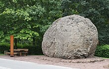
It came to light in 1969 during blasting at a quarry on the volcanic cone, and in the winter of 1980 and 1981 was towed on an iron plate over a compacted layer of snow with a bulldozer into the village centre.
Among the places named in a confirmation document issued by Heinrich VI to Abbot Absalon von Springiersbach are cropfields and meadows at Struhna.
In 1297, Count Heinrich of Luxembourg enfeoffed the knight Richard, Lord of Daun, with the tithes from Stroin.
It bears the year 1483 and this inscription, in archaic German: Maria heißen ich, alle Weder verdriffen ich Claus von Enen gos mich ("Maria is my name, all weather I drive away, Claus von Enen poured me").
On the road from Strohn to Mückeln lies the Herrenbüsch where graves from Roman times can still be found.
Inside, they found jugs still filled with ashes, old coins, swords, amulets and lance heads.
The municipality's arms might in English heraldic language be described thus: Tierced in mantle, dexter vert a lion's head couped Or langued gules, sinister vert a millstone argent surmounted by three ears of wheat laid per pall reversed of the second, in base argent balances of the third.
The tinctures gules and argent (red and silver) stand for the Electorate of Trier; Strohn for centuries belonged to the Electoral-Trier Amt of Daun.