Stryn
Some of the main villages in Stryn include Loen, Innvik, Utvik, Randabygda, Olden, and Flo.
Farming, forestry, fruit growing, animal breeding for furs, small manufacturing industries, tourism, and the service trades provide the main occupations.
The municipality (originally the parish) is likely named after the local river Stryneelva (Old Norse: Strjónar).
The official blazon is "Vert, a linden branch Or in bend sinister with four leaves" (Norwegian: På grønn grunn ein venstre skråstilt gull lindekvist med fire blad).
This means the arms have a green field (background) and the charge is a linden (tilia) branch with four leaves.
The charge has a tincture of Or which means it is commonly colored yellow, but if it is made out of metal, then gold is used.
The municipal council (Kommunestyre) of Stryn is made up of 25 representatives that are elected to four year terms.
The Jostedalsbreen National Park has an area of approximately 1,310 square kilometres (510 sq mi).
Visitors from all over the world come to see the Briksdalsbreen glacier outlet, which is situated amid waterfalls and high peaks.
The resulting flood wave wiped out the settlements of Nesdal and Bødal, killing 135 people.
There are many bird species in this area including the golden eagle (Aquila chrysaetos), rough-legged buzzard (Buteo lagopus), and the white-backed woodpecker (Dendrocopus leucotos).
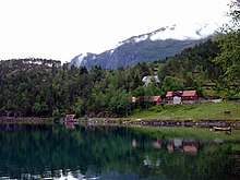
The village of Stryn, a busy and developing small village at the tip of the most northernly of the three short branches at the inner end of Nordfjorden, is the local government and shopping centre for a large community and the junction of roads which connect inner Nordfjord with the rest of Norway.
The southernmost of the three short branches at the inner end of Nordfjorden terminates at the village of Olden from which a lovely valley, Oldedalen, goes due south for about 20 kilometres (12 mi) between slopes rising sharply to more than 1,700 metres (5,600 ft) to the edge of the Jostedals glacier.
Much of the upper Loen valley was devastated from two rockfall slides (one in 1905 and one in 1936) that created huge waves that swept with them most of the houses and vegetation.
On the southern shore of the Nordfjorden, between Hildaneset and Utvikfjellet, lie the villages of Innvik and Utvik, in the area known as Vikane.
The main road (Rv 60) skirts the fjord past Innvik and ascends from Utvik to Utvikfjellet mountain.