Subiaco, Western Australia
It is approximately 3 km (1.9 mi) west of Perth's central business district, in the City of Subiaco local government area.
Historically a working-class suburb containing a mixture of industrial and commercial land uses, since the 1990s the area has been one of Australia's most celebrated urban redevelopment projects.
It remains a predominantly low-rise, urban village neighbourhood centred around Subiaco train station and Rokeby Road.
Subiaco is located approximately 3 km (1.9 mi) west of the central business district (CBD) of Perth, the capital and largest city of the state of Western Australia.
[5][6] Prior to European settlement, the area was inhabited by the Mooro group of the Whadjuk Noongar people.
In January 1846, a group of missionaries led by John Brady, the first Catholic Bishop of Perth, arrived at the port of Fremantle.
In 1846 or 1847, the Catholic Church acquired two lots of land near Herdsman Lake, north of the modern day Subiaco.
[7]: 9–10 [8] In the 1860s and 1870s, investors began buying land in the area, speculating that a railway line would be built eventually.
[7]: 11 In the 1880s and 1890s, Western Australia experienced several gold rushes, causing a rapid increase in population across Perth.
On 13 March 1883, the Government of Western Australia announced it would survey an area of commonage to create suburban lots, to put up for sale.
This covered the area bounded by Thomas Street, Aberdare Road, and the railway line, taking up most of Subiaco, and part of Shenton Park.
[7]: 13 The land was surveyed by Gilbert H. Rotton, who set out the streets in a traditional grid pattern, with large lots.
[7]: 22 Around 1905, the Municipality was given 98 acres (40 ha) of endowment land to use, located north of the railway line and south of Salvado Road.
At a ceremony on 29 August 1912, John Scaddan, the Premier of Western Australia, placed the first brick to be laid by the Workers' Homes Board, at a construction site on Hensman Road, Subiaco.
[7]: 32 In 1927, the Subiaco post office relocated from Civic Square to a larger building on the corner of Rokeby Road and Park Street.
[citation needed] By the late 1940s, the Municipality of Subiaco had reached a high enough population that it was eligible to become a city.
[7]: 42 [17][18] By the late 1940s, many of Subiaco's older buildings were rundown and needing significant repairs, giving the suburb a bad image.
The newer, nearby suburbs of Daglish and parts of Shenton Park were mostly owner-occupied, compared to Subiaco, where most properties were rentals.
Mayor Joseph Abrahams said in 1954 that "within the period of one year the appearance of both Hay Street and Rokeby Road has altered considerably".
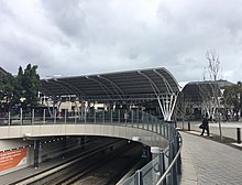
The project was called "Subi Centro" As part of the redevelopment, the Fremantle line was put in a cut-and-cover tunnel for 800 m (2,600 ft), and a new underground Subiaco station was built.
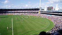
[7]: 63 In October 2020, the state government finalised the "Subi East" redevelopment plan, to follow the demolition of the Subiaco Oval stadium and Princess Margaret Hospital after their closures in 2017 and 2018 respectively.
Blue collar jobs were low, with technicians and trades workers at 6.5%, labourers at 3.6%, and machinery operators and drivers at 1.0%.
The next most common birthplaces were England (8.6%), Malaysia (2.0%), New Zealand (1.9%), Ireland (1.8%), and China, excluding Taiwan and special administrative regions (1.6%).
[citation needed] Residential areas include Subi Centro, a modern housing development with the sunken Subiaco railway station on reclaimed industrial land near Wembley, and older heritage properties towards Shenton Park.
[27] Subiaco has a large number of well-preserved high-quality historic homes, many with elaborate leadlight windows.
Many houses in Subiaco are heritage listed, which recognises their cultural significance and ensures that any changes preserve their unique characteristics.
[34][35][36] Subiaco is also known for its Subi Farmer's Market, held every Saturday morning near the primary school on Bagot Road.
Councillors for the North Ward are Stephanie Stroud and Rosemarie de Vries, whose terms expire in 2023.
This seat is part of the North Metropolitan Region of the Western Australian Legislative Council (upper house).
[69] Along Hay Street and Roberts Road is route 28, which goes between Perth Busport and Claremont railway station on the Fremantle line.