Sucre (state)
In the year 1700, by mandate of his Majesty Felipe V, he sent Captain Pedro Antonio Arias y González Manso to resolve the conflict in the Valley.
Positioning their ships in Carúpano, the siege began up to the Valley of Cumanacoa, a conflict that lasted two years that ended up restoring order and the recovery of all the lands by the Spanish Empire, with the surrender of the indigenous tribes of the region and especially the Cumanagoto, the region of the Valley remains under the control of Captain Pedro Antonio Arias and Gonzalez Manso.
King Felipe V, pleased with this service to the Spanish Empire, sends him Royal orders to establish himself permanently in the Valley with special powers of Governance, Justice and Commerce and to make it a territory that is not subject to the Governor of the province of Nueva Andalucía and Nueva Barcelona as well as his appointment as Señorío de San Baltazar de los Arias.
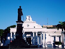
After the events of Caracas in April 1810, commissioners entered Cumaná, a meeting was called to establish a Provisional Board that took over the government of the Province.
When Gran Colombia was dissolved and José Antonio Páez assumed the presidency of Venezuela, the country was divided into 11 provinces, one of which was Cumaná.
In this last earthquake, the surface rupture that occurred in the Pilar Fault segment was particularly irregular, with cosmic displacements of approximately 0.25 m and a process of soil shaking recorded on the coast line.
The main heights of the Eastern Cordillera are Cerro Negro, Peonia, Majagual and Arrempuja, all of them at more than 1900 m., being its highest point the Turimiquire peak with its almost 2600 m.[citation needed] Some of the most important rivers in the State of Sucre are the following Ríos Neverí (117 km.
In contrast, towards the southeast of the entity, in the Gulf of Paria, the land is very flat, with slopes of less than 1% and with insufficient drainage, which has turned it into swampy plains.
[citation needed] In Paria the vegetation ranges from cloud forest at 1000 meters and annual rainfall calculated between 1000 and 1500 millimeters, to xerophytic as we approach the coast.
"[citation needed] The conditions that prevail in the area of the Paria Peninsula favor the presence of important bird species and subspecies new to science that live only inside the park, such as the colorful earwig hummingbird.
[citation needed] In the Eastern Cordillera bioregion, where almost the entire state is included Sucre, except for the muddy plain, 125 species of mammals have been recorded, equivalent to 38.2% of the national total (20).
[citation needed] Among the mammals reported in the bioregion, not including the Araya Peninsula find the common cachicamo (Dasypus novencinctus), the cuchicuchi (Potos flavus), the red deer (Odocoileus virginianus).
The swampy plain of the Ajíes-Río San Juan stream covers a small area of the bioregion of the deltaic system, where fewer mammals have been recorded, only 96, equivalent to 29.3% of the national total.
[citation needed] In the western coastal area, a semi-arid climate can be observed, with an average annual temperature of 24-26 °C in Cumaná and rainfall of 375 mm.
In the southern parallel strip, a rainy tropical savanna climate is observed, which extends to the area of the coastal slope to the Caribbean Sea.
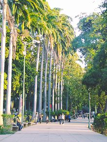
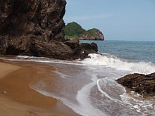
[citation needed] The main tourist areas are the Mochima National Park with varied Caribbean seascapes, large beaches and small islands throughout, several species of birds, fish, molluscs and other animals.
[citation needed] The following protected islands in Mochima National Park belong to the State of Sucre The Trunk 9, the coastal road that allows access to Cumaná, Carúpano and Güiria, is The "Ruta del Sol" is characterized by views of the Altos de Santa Fe and Cariaco.
[citation needed] The natural environment of the state of Sucre includes the mountains of Araya-Paria, Turimiquire, San Bonifacio and La Paloma; the intermontane landscapes, represented by the valleys, foothills and hills; the extensive coastline of the Gulfs of Cariaco and Paria, and the Caribbean Sea, where you can find coral reefs, beaches, capes and coves, as well as the extensive fluvial-marine plain of the San Juan River-Aruca River.
[citation needed] Among the beaches are Arapito, Colorada, Varadero, Playa Blanca and Mochima, located in Mochima National Park, and the existing ones in the northern coast of the Paria peninsula such as Chaguaramas, Medina, Puipuy, San Juan of Las Galdonas, Querepare, Pargo, Uquire and San Francisco.
On the south coast of the peninsula of Paria requires special mention those of Macuro, Yacua, Mapire, Rio Grande and Cauranta.
Through the Trunk Road 10, in the north–south direction, it links with Maturín and Puerto Ordaz, the capital of Monagas and the main city of the state of Bolivar, respectively.
Ferries and other boats that arrive at the port depart from this maritime terminal to Punta de Piedras, on Margarita Island, and Araya, a town located on the peninsula of the same name in the northwestern end of Sucre State.
of Indian origin, which crossed the Gulf of Paria due to the proximity of the island of Trinidad, where the British employed abundantly.