Sugarloaf Mountain (South Carolina)
[3] This site is located within the Sand Hills State Forest, adjacent to U.S. Highway 1, in the Carolina Sandhills region of the Atlantic Coastal Plain.
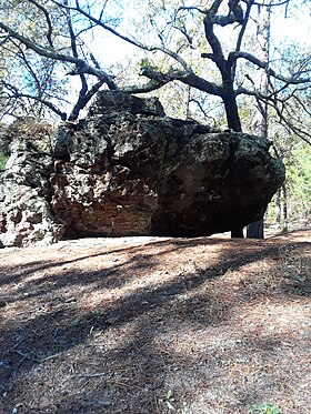
On published geologic maps of the area, Sugarloaf Mountain is mapped as part of the Middendorf Formation, a sequence of sandstone, pebbly sandstone, sand, silt, and clay that are interpreted as fluvial (river) deposits that accumulated during the Cretaceous Period.
[4][5][6] While much of the mountain is composed of unconsolidated to semi-consolidated beds of quartz-rich sand, silt, and clay, outcrops and boulders of iron-cemented, pebbly sandstone can be found both on the mountain-side and the immediate vicinity.
There are timber rattlesnakes, black racers, and water moccasins during the spring, summer, and fall.
Be cautious and alert for wildlife To get to the base of the mountain, stop just past camp site number 6 and it is on the left.
"Trails of red clay and patches of white sand through an assorted forest of new and old growth dogwoods, pine, and hardwoods.
During your ride you may encounter deer, fox squirrels, turkey, and possibly an elusive red cockaded woodpecker.
Nearby, there is a large pond, (no swimming), that contains fish such as bream, redbreast, and crappie.