Suiattle River
Snowmelt from Chocolate and Dusty Glacier gives the river silty water, with a suspended load over twice that of the upper Sauk or adjacent White Chuck.
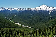
The Suiattle watershed is heavily forested and undeveloped, with human use mainly limited to outdoor recreation such as use of the Pacific Crest Trail, which passes over the river.
It turns sharply north as it passes into Skagit County east of Prairie Mountain, and receives its last major tributaries, Tenas and Big Creek.
[7] It flows south of Suiattle Mountain and makes its confluence with the Sauk between Darrington and Rockport, with its mouth elevation around 400 ft (120 m).
The river valley is the driest region of the Darrington Ranger District, as the various surrounding ridges and peaks serve to drain incoming storm systems.
Between 1,500–3,500 ft (460–1,070 m) in elevation, the river valley enters a transitional snow zone, where winter storms can produce rain or snow depending on temperature variations; this can result in "rain-on-snow" storms where rain melts previous snowfall and creates floods, often the peak flow of a given year.
[3] The river valley below the confluence with Downey Creek (around 1,390 ft (420 m) in elevation) only sees occasional snowfall during winter storms.
[12] The total suspended load of the Suiattle is estimated at 680 tons per square kilometer per year, over twice the yields of the adjacent upper Sauk and White Chuck rivers.
Glacier Peak underwent an intense eruption around 13,000 years ago, sending large lahars down the Suiattle.
[15] Due to the Suiattle's relatively dry conditions in comparison to other western Cascade river valleys, elevational vegetation zones are shifted upwards.
The broader watershed supports a variety of mammal species, including grizzly bears, wolves, wolverines, and martens.
Deer populations in the valley fluctuate in response to wildfires and timber harvesting, increasing as tree-clearing allows for greater forage, and decreasing as conifer canopy limits surface plant growth.
Despite these protections, the Federal Energy Regulatory Commission approved plans for a dam along the Suiattle in violation of the Wild and Scenic Rivers Act.
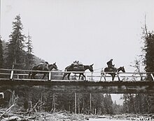
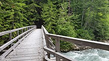
A new 282 ft (86 m) bridge was built in 2011 in a more stable location, adding about 4 mi (6.4 km) to the Pacific Crest Trail route.
However, while its contributing streams are generally pristine, riparian degradation including logging has occurred along parts of the main stem.