Surigao del Norte
[3] The province comprises two major islands—Siargao and Bucas Grande—in the Philippine Sea, plus a small area at the northeastern tip of mainland Mindanao and other surrounding minor islands and islets.
[8]: 141–142 The explorer Ruy López de Villalobos headed an expedition to Surigao in 1543, an attempt at subjugation which failed because of the resistance of the natives.
By the end of the Spanish rule in 1897, Agusan had been organized as a single politico-military comandancia named "Butuan", within the administrative jurisdiction of Distrito de Surigao.
On December 23, 1898, the last Spanish Governor of Surigao turned his authority over to a provisional Filipino "Junta Provincial" Peacefully.
[9] The Junta Provincial elected Jantoy Gonzalez to serve as the Provisional head while waiting for the arrival of the new authority from Luzon that was sent by Aguinaldo.
His diaries are currently stored in the Jesuit archives at Centro Borja, Sant Cugat del Valles, Spain.
He thus wrote on December 26, 1898, "Before 10:00 AM, the tri-color was hoisted from Casa Real seat of provincial government) and the Tribunal … without any formalities … without anybody's attention being drawn…..these people have no idea of what it is all about, and if they have… how peaceful and without malice they are.".
Don Prudencio Garcia staged a coup which resulted in the imprisonment of the Gonzalezes (Jantoy, Simon, and Wencaslao), and were killed shortly after in Cortez (now Surigao del Sur).
Aguinaldo was given a message from an "unknown correspondent" which stated"General Simon Gonzales and his brother Wencaslao, the Governor of Surigao has been assassinated for collecting excessive contribution in money for the war, and their successors have also been assassinated by the Moros who form a greater part of the population and who have revolted against Filipino rule" (Philippine Insurgent Record 1039.5 in Taylor)the letter stated that the Gonzales were assassinated, and that the Moros were blamed for the deaths of the predecessors despite having barely any Moros in Surigao by that time.
The area of the conflict is located at the present day Surigao Luneta Park and alongside the street of Borromeo.
[14] Dinagat Islands had been a part of the First District of Surigao del Norte until becoming a province on its own on December 2, 2006, with the approval of Republic Act No.
Between February 2010 and March 2011, the islands were part again of Surigao del Norte after declaring RA 9355 unconstitutional by the Supreme Court, then were reinstated as a separate province.
The province, with an area of 1,972.93 square kilometres (761.75 sq mi),[1] comprises the mainland situated at the northeastern tip of Mindanao and several offshore islands, the largest of which include Siargao and Bucas Grande.
Some islets which include those in Del Carmen in Siargao Island are a cluster of rock formations jutting out from the sea covered with shrubs and coconut trees.
Surigao del Norte has no pronounced dry season, receiving maximum rainfall from November to January.
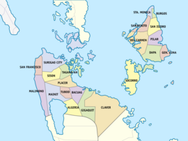
[16] Surigao del Norte comprises 20 municipalities and 1 component city, organized into two legislative districts and further subdivided into 335 barangays.
Mangroves are the major vegetation in the coastal areas of the province, which form interminable marine forests covering 175 square kilometres (68 sq mi) along the coasts of the mainland and the islands of Siargao and Bucas Grande.
Marlin, tuna, lapu-lapu, mollusks, crabs, even squids, stingrays and octopuses can be bought from fish vendors and fishermen.
The Bonok-Bonok depicts the native folks' merry-making to show gratitude to God for bountiful harvest and good health.
A collection of ancient archaeological diggings like burial coffins, jars and Chinese ceramics unearthed in Panhutungan, Placer, is on public display at the Surigaonon Heritage Mini-Museum located at the Boulevard in Surigao City.
On the northern side of the province are Siargao and Bucas Grande Islands, known for their long stretch of sugar-fine beaches, vast mangrove forest, and deep waters teeming with marine life.