Sydney Cove West Archaeological Precinct
The absence of an archaeological record for the Cadigal (even allowing for large-scale city development) has led Karskens to believe that Sydney Cove was likely to be border country for the Eora nation and therefore possibly was not inhabited prior to European settlement.
It is likely that the First Fleet disembarked on the western side of Sydney Cove, along a foreshore of small sandy beaches and rocky outcrops that extended north from the present day MCA building.
Governor Phillip's instructions prohibited the construction by private individuals of vessels capable of making contact with established ports within the region, or of trading within the area subject to the East India Company's monopoly.
Phillip ordered that boats being built by private individuals were to be limited to fourteen feet (c. 4 metres (13 ft)) in length, to prevent escape attempts by convicts.
Isaac Nichols (an emancipated convict, later assistant to the Naval Officer, publican, trader and postmaster) built his first house, close to the Hospital Wharf.
[1] The first Market place, where storeholders and traders sold goods, was located on the western side of Sydney Cove between High (George) Street North and the Hospital Wharf (in present-day First Fleet Park).
In 1811 Governor Macquarie relocated the Market place to further south along George Street at the site of the present day Queen Victoria Building, where it was served by a new wharf in Cockle Bay.
The Commissariat Stories provided secure and vermin-proof storage of government provisions such as food (grain and vegetables grown in the colony), clothing, shoes, blankets, imported tools and equipment.
In the 1822 Macquarie's report to the Secretary of State for War and the Colonies, Earl Bathurst (on his return to England) details his works at the dockyard:[2][1] The Old Dockyard enlarged and greatly improved the new Building and repairing Docks, Wharfs, Quays, Sail Rooms, and all the requisite workshops, including Boat Houses, and also Offices for the Master Builder and Master Attendant of the Colonial Marine, the whole of the Premises being enclosed with a Stone Wall, 12 feet high.
The naval portion of the work is performed by gangs of competent convicts from the barrack; the jail-gang being usually tasked with the lading and unlading of vessels.Between 1830 and 1831 extensions to George Street Commissariat Store building.
In November 1833, a brig, Ann Jamieson, ignited and exploded while unloading a cargo of gunpowder and bar iron at the Kings Wharf, burnt to water level and sank.
During 1889 and 1892, demolition (for extensive road widening) of Isaac Nichols' and Mary Reibey's houses along with other buildings on the east side of George Street in the vicinity of Queens Wharf (present day First Fleet Park).
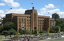
[1] In 1936 the site for a new head office for the Maritime Services Board was chosen on the west side of Circular Quay in close proximity to the Department of Labour and Industry.
[1] The former dockyard site extends across the eastern extremity of Argyle Street and includes Bligh and Barney Park and land owned by the Sydney Harbour Foreshore Authority immediately in front of Cadman's Cottage's SHR curtilage..
The southern boundary was the Hospital/Kings/Queens Wharf (located in present-day First Fleet Park, immediately south of the 1952 former Maritime Services Board (MSB) building, now the MCA).
[1] During 1822 and 1823 the storehouse (later the Colonial Storekeepers Building) was built at northern end of dockyard, immediately south of Cadman's Cottage (within Bligh and Barney Park).
The two wings had large openings on their eastern facades (that faced the waterfront) each with a cats eye fixed beneath the roof line for loading goods into the warehouse.
[1] The 1812 George Street building was constructed as the provision store, granary and office for the Commissariat under Governor Lachlan Macquarie's authority, also using convict labour.
The market place was marked and named on Surveyor Meehan's 1807 map as a triangular public space at the junction of George Street and Hospital Wharf.
The market place was relocated by Governor Macquarie in 1810-11 to further south down George Street (the site of the present day Queen Victoria Building) where it was now served by a new wharf in Cockle Bay.
In 1833 the brig Ann Jamieson ignited and exploded while unloading a cargo of gunpowder and bar iron at the Kings Wharf, burnt to the water level and sank.
This was interpreted as a retaining wall built in the 1850s when Argyle Street was extended eastwards over the infilled dockyard to the newly created Circular Quay waterfront.
Other remains, including wall footings and large sandstone slab drains, were located in limited testing under Argyle Street and under the adjoining Bligh and Barney Park.
This information strongly invalidates the site assessment in The Rocks and Millers Point Archaeological Management Plan (1991) which stated that the Museum of Contemporary Art (MCA) area was likely to be completely disturbed.
The construction of the former Maritime Services Board building (the present MCA) in 1946-52 was accompanied by the raising of the ground level of the landscaped and park areas by 40 to 59 centimetres (16 to 23 in).
Sydney Cove West Archaeological Precinct has state significance for its associations with Governor John Hunter, who established the colonial dockyard in 1797; with the military administrator Lieutenant Colonel Joseph Foveaux who commissioned and started the Commissariat Stores building in 1809; with Governor Macquarie who completed the 1810 and commissioned the 1812 Commissariat Stores buildings and improved and enlarged the dockyard in 1818–22 with additional premises and four new docks; with significant early emancipists Isaac Nichols and Mary Reibey who built their residences, warehouse and the colony's first post office on the site of First Fleet Park between 1798 and 1811; with the convicts of the Third Fleet who disembarked at Hospital Wharf in 1791, and with Lieutenant-Colonel George Barney, colonial engineer, for the construction of this section of Circular Quay between 1844 and 1859.
It remained a significant example of the earliest colonial infrastructure and in continuous use for 130 years by naval and government departments and commercial tenants until its demolition in 1939 for the Maritime Services Board headquarters (now the Museum of Contemporary Art).
Recent ground penetrating radar survey of First Fleet Park indicates potential archaeology of the early commercial and residential precinct that included buildings associated with Isaac Nicholls and Mary Reibey.
The site is associated with Governor John Hunter, who established the colonial dockyard in 1797; with the military administrator Lieutenant Colonel Joseph Foveaux who commissioned and started the Commissariat Stores building in 1809; with Governor Macquarie who completed the 1810 and commissioned the 1812 Commissariat Stores buildings and who improved and enlarged the dockyard in 1818–22 with additional premises and four new docks; with significant, early emancipists Isaac Nichols and Mary Reibey who built their residences, warehouse and the colony's first post office on the site of First Fleet Park between c.1798 and 1811; with the convicts of the Third Fleet who disembarked at Hospital Wharf in 1791, and with Lieutenant-Colonel George Barney, colonial engineer, for the construction of this section of Circular Quay between c.1844 and 1859.
The site contains the identified and predictive archaeology of the first colonial Government dockyard in Australia (dating from 1797 and enlarged by Governor Macquarie 1818–22); the 1810 and 1812 Commissariat Stores buildings, and the 1840s and 1850s seawall constructed for Circular Quay.