Syunik Province
The Vayots Dzor Province of Armenia forms its northern border, while Aras River at the south separates Syunik from Iran.
However, only one was detected by camera trap between August 2006 and April 2007, and no signs of other leopards were found during track surveys conducted over an area of 296.9 km2 (114.6 sq mi).
The local prey base could support 4–10 individuals, but poaching and disturbance caused by livestock breeding, gathering of edible plants and mushrooms, deforestation and human-induced wildfires are so high that they exceed the tolerance of the leopards.
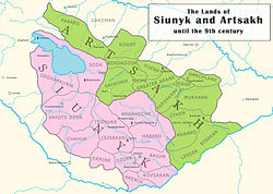
Inscriptions found in the region around Lake Sevan attributed to King Artaxias I confirm that the historic province of Syunik was part of the Artaxiad Kingdom of Armenia during the 2nd century BC.
The Syunik Province was later governed by Vahan (c. 570), Philip (Philipo, c. 580), Stephen (Stephanos, c. 590–597), Sahak (Isaac, c. 597) and Grigor (Gregory, until 640).
In 826, Sahak allied with his ancient enemy – Sevada, the Qaisite emir of Manazkert – against the governor of Caliph, but he was defeated and died in Kavakert.
A general sent by the Caliph, Bugha al-Kabir, destroyed Armenia and Aghuania in these years and sent a detachment to Eastern Syunik where was governing Vasak IV with his brother Achot.
The people of Syunik were sheltered in the fortress of Balq, but Vasak fled to Kotaiq, and was pursued to the region of Gardman on the eastern border of Lake Sevan.
[citation needed] The Caliphate tried to control all these regions, and for this reason, Bogha decided to repopulate the city of Chamkor in the Kura River with Muslims.
Sembat submitted, was forgiven and married to the sister of the prince of Vaspurakan, receiving the city and district of Nakhchivan, which in 902 was upset with the Kaysites or Qaisids.
Sembat was sheltered in the fortress of Erendchak (today Alinja, northeast of Nakhchivan) and Yusuf remained owner of Eastern Syunik.
[citation needed] Seneqerim Ioan was followed by his son Grigor of Syunik and Aghuania, who governed until 1166 when the country was conquered by the Seljuq Turks.
It mostly had autonomous rule and was for some periods fully independent under the Armenian meliks Later, the Orbelian dynasty, one of whose members wrote an important history of the country, governed Syunik in times of Timur (Tamerlan) as vassals.
Following the Russo-Persian War of 1804–13, Syunik -along with the rest of Karabakh Khanate- passed into Imperial Russian possession, officially signed in the Treaty of Gulistan in 1813.
When the Elisabethpol Governorate was established in 1868, the region became part of the Zangezursky Uyezd, with its administration based in the town of Geryusy starting from 1870.
[18] The beginning of 20th century saw an outbreak in ethnic tensions between the Armenian and Tatar populations in the Caucasus, culminating in the Armenian-Tatar massacres.
[21] According to Thomas de Waal, the dispute over Syunik resulted in the displacement of region's Caucasian Tatar minority through direct military action by Armenian guerrilla commanders Andranik,[22] Rouben Ter Minassian[23] and later Garegin Nzhdeh.
[25] Between April and July 1921, the Red Army conducted massive military operations in the region, attacking Syunik from the north and east.
After the conflict, Garegin Nzhdeh, his soldiers, and many prominent Armenian intellectuals, including leaders of the Republic of Armenia, crossed the border into the neighbouring city of Tabriz in Persia.
[citation needed] Armenian forces eventually secured the region but their efforts were in vain when the Bolsheviks, successful in the Russian Civil War, pushed deep into the Caucasus.
Syunik was one of the last major holdouts of the independent Armenian state whose leaders were eventually expelled by incoming Soviet authorities to Iran.
Despite the region's troubled early years in the Soviet Union, it gradually began to recover with much of the area's infrastructure rebuilt and improved.
[34] The ninth point of the 2020 Nagorno-Karabakh ceasefire agreement that ended the 2020 war stated that "All economic and transport connections in the region shall be unblocked.
[37] Prime minister of Armenia Nikol Pashinyan rejected this, arguing that the ceasefire agreement does not call for a corridor through Syunik but for the general opening of transportation routes between the two countries.
As a result of the administrative reforms took place on 24 November 2015, 17 June 2016 and 9 June 2017, Syunik is currently divided into 8 municipal communities (hamaynkner), of which 5 are urban, and 3 are rural:[42][43][44][45] Near the village of Angeghakot in the Sisian Municipality is located the prehistoric site of Godedzor that goes back to about 4000 BC.This was an important centre for obsidian trade in Syunik obsidian.
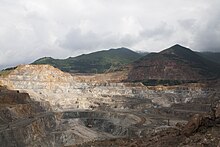
The economy is of the province is mainly based on the industrial sector, including mining, building materials production and food-processing.
The prospect of a uranium mine being exploited by the Russian State Nuclear Energy Corporation (Rosatom) in the village of Lernadzor.
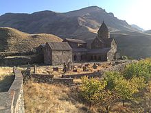
The Wings of Tatev (Armenian: Տաթևի թևեր Tatevi tever) cableway, operating since 16 October 2010 between Halidzor and the Tatev monastery, is the longest reversible aerial tramway built in only one section, and holds the record for Longest non-stop double track cable car with the length of 5.7 km (3.5 mi).
[60] Many forests and woodlands of Syunik are among the protected areas of Armenia such as the Arevik National Park and Shikahogh State Reserve.
The province has also the wildlife sanctuaries of Boghakar, Goris, Sev Lake, Zangezur and the Plane Grove of Shikahogh river.