T Third Street
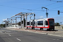
It runs along the east side of San Francisco from Sunnydale to Chinatown, traveling in the median of Third Street for most of its length before entering the Central Subway as it approaches downtown.
The line continues south through Dogpatch and across Islais Creek into the Bayview and Hunters Point neighborhoods.
The line crosses the U.S. Route 101 freeway, where Third Street becomes Bayshore Boulevard, and continues south in the median.
[7] Construction of the line was proposed in the late 1980s as plans for the redevelopment of the Mission Bay neighborhood were established.
The loop was originally designed in 1998 as part of the Third Street Light Rail project, but was deferred due to insufficient funding.
[13] The underground section of the line was closed west of Castro station from June 25 to August 24, 2018, due to the Twin Peaks Tunnel shutdown.
[20] Light rail service was re-replaced with buses on August 25 due to issues with malfunctioning overhead wire splices and the need to quarantine control center staff after a COVID-19 case.
[25] As part of the January 2021 service change, Muni also added the 15 Bayview-Hunters Point Express bus route.
The route makes local stops in the Bayview–Hunters Point neighborhood east of Third Street and limited stops on Third Street paralleling the T.[26][27] The second phase of the line was built as the Central Subway, which forms a crosstown link between South of Market (SoMa) and Chinatown via Union Square.
[30] After numerous delays, the Central Subway opened on November 19, 2022, with a weekend-only shuttle service operating between Chinatown and 4th and Brannan.
[34] The Central Subway will be closed from February 26 to March 14, 2025, for water leakage mitigation at Chinatown station.