Table Mountain
'sea-emerging'; Afrikaans: Tafelberg) is a flat-topped mountain forming a prominent landmark overlooking the city of Cape Town in South Africa.
The plateau, flanked by Devil's Peak to the east and by Lion's Head to the west, forms a dramatic backdrop to Cape Town.
This broad sweep of mountainous heights, together with Signal Hill, forms the natural amphitheatre of the City Bowl and Table Bay harbour.
It is better known by the names of the conservation areas on its lower slopes: Groote Schuur Estate, Newlands Forest, Kirstenbosch Botanical Gardens, Cecilia Park, and Constantia Nek.
Devil's Peak, Signal Hill, the City Bowl and much of the "Cape Flats", however, rest on heavily folded and altered phyllites and hornfelses known informally as the Malmesbury shales.
[9] The basement rocks are not nearly as resistant to weathering as the TMS, but significant outcrops of the Cape Granite are visible on the western side of Lion's Head, and elsewhere on the Peninsula (especially below Chapman's Peak Drive, and The Boulders near Simon's Town).
When these softer layers eroded away, they left a very hard, flat erosion-resistant quartzitic sandstone platform behind which today forms Table Mountain's top.
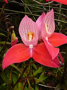
Although they are quite widespread on the Back Table, the best (most certain, and close-up) place to view these beautiful blooms is in the "Aqueduct" off the Smuts Track, halfway between Skeleton Gorge and Maclear's Beacon.
[20] In the early 1900s commercial pine plantations were planted on these slopes all the way from the Constantiaberg to the front of Devil's Peak, and even on top of the mountains, but these have now been largely cleared allowing fynbos to flourish in the regions where the indigenous Afromontane forests have not survived, or never existed.
[23] This was originally probably to maintain a productive stock of edible bulbs (especially watsonians)[23] and to facilitate hunting, and later, after the arrival of pastoralists,[24] to provide fresh grazing after the rains.
[23][22] Thus the plants that make up fynbos today are those that have been subjected to a variety of fire regimes over a very long period time, and their preservation now requires regular burning.
Despite intensive conservation efforts the Table Mountain range has the highest concentration of threatened species of any continental area of equivalent size in the world.
Other invasive plants include black wattle, blackwood, Port Jackson and rooikrans (All Australian members of the acacia family), as well as several Hakea species and bramble.
In addition, their sleeping sites are noted each evening, so that monitors armed with paint ball guns can stay with the troop all day, to ward them off from wandering into the suburbs.
As an exotic species, they were almost eradicated through a culling programme initiated by the South African National Parks to make way for the reintroduction of indigenous klipspringers.
On the lower slopes of Devil's Peak, above Groote Schuur Hospital an animal camp bequeathed to the City of Cape Town by Cecil John Rhodes has been used in recent years as part of the Quagga Project.
The pastoralist influx brought herds of cattle and sheep into the region, which then formed part of a larger grazing land that was seasonally rotated.
Between 1896 and 1907, five dams, the Woodhead, Hely-Hutchinson, De Villiers, Alexandria and Victoria reservoirs, were opened on the Back Table to supply Cape Town's water needs.
A ropeway ascending from Camps Bay via Kasteelspoort ravine was used to ferry materials and manpower (the anchor points at the old top station can still be seen).
Following another big fire in 1991, Attorney General Frank Kahn was appointed to reach consensus on a plan for rationalizing management of the CPPNE.
The most recent major fires include those of January 2006, which burned large amounts of vegetation and resulted in the death of a tourist (a charge of arson and culpable homicide was laid against a British man who was suspected of starting the blaze), and March 2015.
The upper cable station offers views overlooking Cape Town, Table Bay, Lion's Head and Robben Island to the north, and the Atlantic seaboard to the west and south.
The Bridle Path, or Jeep Track, makes a more gradual ascent from Constantia Nek along the road used to service the dams on Back Table.
There are many other paths in popular walking areas on the lower slopes of the mountain accessed from Constantia Nek, Cecilia Park, Kirstenbosch, Newlands Forest and Rhodes Memorial.
There is a popular "Contour Path" that runs from Constantia Nek, and then, in succession, above Cecilia Park, Kirstenbosch Botanical Gardens, Newlands Forest, and from there, above Groote Schuur Estate, past the King's Blockhouse, at the north-east corner of Devil's Peak, immediately below the Mowbray Ridge cliffs, to the front of Devil's Peak and the north face of Table Mountain, ending at the bottom of Kloof Corner Ridge at the western end of the Table Mountain cliffs.
From the King's Blockhouse it is possible to choose a footpath that will lead to the "upper contour path" which traverses the front (north face) of Devil's Peak and Table Mountain at 500 m, to just beyond the Lower Cable Station.
[47][48] On top of the mountain, and particularly on the Back Table, there is an extensive network of well marked hiking paths over a variety of terrains and distances and durations up to several hours or all day.
[47] Maps of all the routes are available at bookshops and outdoor recreation stores, which hikers are advised to use, as dense mist and cold weather (or extreme heat) can descend without warning at any time of the year.
[50] SANPARKS arranges for luggage and provisions to be transported to the operational cottages and tented camps, so that the hikers can ascend the mountain unencumbered by heavy backpacks.
The biggest systems are the Wynberg Caves, located on the Back Table, not far from the Jeep Track, in ridges overlooking Orange Kloof and Hout Bay.